Chalking up the Hampshire Downs
Exton to Buriton
We left you last week with a rant about the conservation of the chalk rivers of south and east England. It’s not often that one region of the UK has a majority share holding in a global ecosystem, but even this obligation does not always concentrate minds on the long view. The short term costs of treating threats such as water pollution can appear far more scary than the long term, and less tangible, benefits of a beautiful, clean, biodiverse, trout stream. These chalk rivers are capable of delivering oodles of human physical and mental well being, as well as significant contributions to the longevity of the planet. Conservation work is underway, however, the Meon Valley Partnership is a case in point. http://www.meonvalleypartnership.org.uk
Back at Exton it is Day 2 of our Hampshire Downs trek; the river Meon looks as stunning as it did the evening before, and the village itself amply fulfills the expectation of ridiculously pretty domestic, rural Hampshire. The pub looks just as shut, but that was our fault for arriving at silly times.
Easing our feet back into fresh socks and well-used boots, we now face 14 miles of extraordinary chalkland variety. The map suggests considerably more woodland than Day 1, but only hints at a number of surprises which the walk has in store for us.

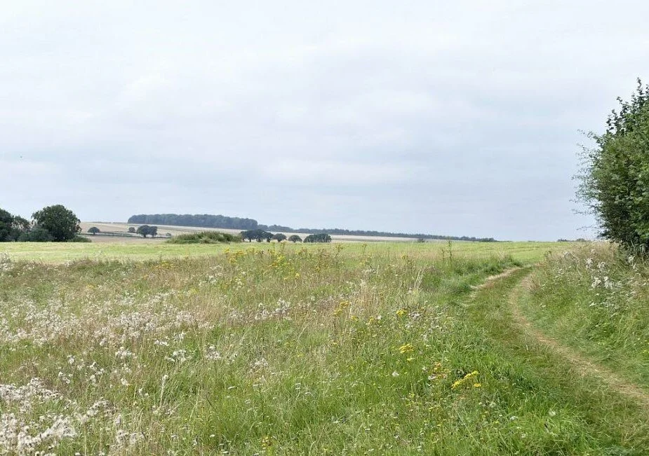
Old Winchester Hill was the first climb of the day and delivered bountiful rewards. The National Nature Reserve was stunning in terms of habitat variety - wild flowers, scrub, grassland - and abundant butterflies and other invertebrates. Above us, hang gliders caught and spilled the breeze and the rampart of the iron age hill fort appeared to encircle the hill top with a green choker.


The tapestry of agricultural landscapes which accompanies this section of the South Downs Way is exceptionally varied, but sometimes farming just will not pay the bills. Business diversification may become essential, when attempting to create new revenue sources from the capital land resource.


Below Old Winchester Hill, we found some classic examples of new uses for old buildings, and new incomes for under-earning land - and water.
A farmyard converted to art …


… and an old estate embracing fishing and glamping.


The second climb of the day, from Coombe Cross to the top of Wether Down (234 m), made Old Winchester Hill seem like a stroll in the park. Here the atmosphere was very different. This is Hang Gliding heaven and home to a variety of airborne gadgets and enthusiasts, as well as a trig point and a collection of communication masts and support gear.
The track down is hard and stony, like so many sections of the South Downs Way, and deposits you in an ingongruous mix of former MOD land, redundant razor wire, a small holiday complex and a new estate of sumptuous residences, each set in a garden the size of a couple of paddocks. Time to move on.
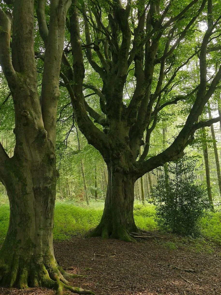
The Way now approaches Hyden Wood, a substantial mixed woodland with some spectacular beech stands which give respite to the eyes and a lift to the heart. But once again it is hard on the feet (none of that soft, North Downs mud), and the next couple of miles are all forest track and country lane. Clean for the boots but tough on the joints.
We also know what is coming next - the Queen Elizabeth Country Park, renowned for its gradients. The Way spares us all but the flanks of Butser Hill (remember that top height of 271 m?) but the track surface and the view on the way up that flank, are somewhat unpreposessing. Imagine the relief, therefore when we emerged at the top of a wonderful, grassy slope, which launched itself down the incline, calling out for us to follow. Better on a mountain bike, of course, but wonderful on foot too. Unfortunately, there is a tarmac snake lying in wait for us at the bottom of the valley. Just as we had to negotiate the M3 on our way from Winchester, now we have cross the A3 to attain the final ascent of the day, through the Queen Elizabeth Forest.


After the heady environment of the grassy slope, the search for the A3 underpass is a real anti-climax. Downland turf turns to urban concrete and the noise levels are rising all the time. We hurry through the underpass and enter the thickness of the forest, expecting an enveloping peace to fall at any moment. But the Way lies parallel to the dual carriageway and the constant, yammering roar of massed internal combustion engines follows us for nearly a mile.
Finally the clamour fades as we begin the long plod up the tree-encrusted chalk of War Down, tired now and tripping on the flint and tree root track. Cresting the last rise, we tip over the edge of the down and into the welcoming arms of a car park, complete with waiting back-up vehicle. We don’t even have to walk off piste to reach Buriton village but are driven straight to the pub.


We have completed the 1987 extension of the South Downs, from Winchester to Buriton. The next stage will take us to West Harting Down and into Sussex. But we will keep that for another time.
After a long draft of St Clements, even the main occupant of the pub car park can raise a smile.
South Downs Way - the Hampshire Downs
Southdown thyme: “ ’You don’t get nothing like that in the Weald. Watercress, maybe?’ said Mr Dudeney.”
Rudyard Kipling, Rewards and Fairies

Last winter, Terroir relatives, while battling with Covid Cabin Fever, announced that they were going to walk the South Downs Way, from west to east in September 2021. Would we like to join them? We said we would.
Given that a lot of us think we know what to expect of the South Downs Way, it is surprisingly unpredictable and idiosyncratic. Is it similar to the North Downs Way? No. Well, that’s that one out of the way. You want detail? The South Downs Way has less mud and a whole lot more easy-to-reach seaside.


But both chalk ridges share some basic characteristics which are significant in the development of the ancient network of tracks and paths which underpin the modern long distance trails. Chalk drains freely and is easier to clear of woodland than the heavy soils of the clay Weald lands and a pastoral economy, based on sheep, is feasible. The chalk ridges also provide height (North Downs top height is 294 m/963 ft on Leith Hill and South Downs 271 m/889 ft on Butser Hill). This provides great visibility if you feel threatened, need to build a fort or just want a great view of the Isle of Wight or London.
Kipling’s 1910 story, ‘Rewards and Fairies’, illustrates the ancient tensions between the “messy trees in the Weald” and Shepherd Dudeney’s “bare, windy chalk Downs”. If you want a feel for the contrasting magic of the chalk lands and the clay Weald, ‘listen in’, as the children Una and Dan do, to the discourse between Puck and the ‘half naked man’ (The Knife and the Naked Chalk).
By the latter part of the 20th century, the need was felt to understand and conserve landscapes, resulting in the National Parks movement and creation of Areas of Outstanding Natural Beauty. The development of the Sussex Downs Area of Outstanding Natural Beauty (AONB) and the South Downs Way (SDW) were understandably interwoven. The trail was approved in principle in 1963, the South Downs AONB established in 1966 and the SDW finally opened in 1972, linking ‘chalk’s end’ Eastbourne, in East Sussex, to the village of Buriton in – shock horror – not West Sussex, but just over the border in Hampshire.
With the increasing rumble and ground swell to turn the Sussex Downs and neighbouring Hampshire Downs AONB into a National Park, the two Natural Beauties transformed into Conservation Boards and Joint Committees until they finally metamorphosed into a single South Downs National Park butterfly in 2010. The South Downs Way was already there; it had been extended from Buriton to Winchester as early as 1987.

Apart from the dry walking conditions (of which more anon), the South Downs Way is also unusual amongst National Trails for being largely bridleway. It is hugely popular with cyclists to the extent that alternative routes and walker-only sections have had to be invented. The Way is extraordinarily well signed but anyone who is poor on pictograms or colour blind could find navigation a nightmare.
Terroir had been pottering around the Sussex end of the SDW for decades, either section-walking or incorporating lengths into stunning, downland circular rambles. Access can be surprisingly sustainable, with careful use of trains and – the increasingly infrequent - buses. We seldom go the extra mile(s) to the western, Hampshire end, however, so we elected to join the walking party at the beginning of the expedition and hike from Winchester to Exton, and then Buriton. Here is the expedition story.
Winchester to Exton
The support team dropped us in Bridge Street, central Winchester, where the starting point, a silvered wooden block, buried in Salvia ‘Hot Lips’, lies outside the City Mill and, possibly more importantly, a cafe (both closed when we were there!). Illustrated at the top of the Blog, the block’s spiky, orange ‘hair cut’ actually represents the alarmingly exaggerated path gradients which await us.
By necessity, the first mile is urban, but no one can argue with a stroll along the River Itchen, before a short amble through some embarrassingly mixed, Winchester-fringe, architecture. The initiation ceremony continues with a hellish crossing of the M3, but despite feeling like prisoners, we survive and emerge, relatively unscathed, onto gently undulating chalk farmland. A classic, chalkland, fruiting hedgrow completes the PTSD healing process (despite a certain urban fringe unmanaged look), with massed privet, hawthorn, blackthorn sloes and rose hips.


Two things struck us about the day’s walk. The defined chalk ridge which characterises the Sussex section of the Way, is lacking here and reminded me more of a domesticated Salisbury Plain, than the South Downs. The northern-based members of the party also commented on this rolling plateau/valley combination rather than the chalk scarp-and-dip slope with which we are all more familiar.
The second factor which particularly struck the south easterners is the large scale of the agricultural landscape and its accompanying architecture, in comparison with the far smaller and more vernacular domestic buildings of the villages and outlying cottages. To us, it read as though the villages had retained their pre 20th century quaintness, while new infrastructure (piped water, drains, electricity etc) had eliminated draughts, leaky roofs, smokey kitchens and outside privies, and 21st century maintenance techniques had retained and enhanced the charm and beauty of a former era. Meanwhile, agriculture had, with a few exceptions, moved forward to embrace much larger scale operations, with vast fields of wheat, barley and oilseed, plus massive investment in machinery, in additives to keep the thin chalk soils producing, and in massive, functional buildings to support the whole operation.


Upper row: the domestic and vernacular. Lower row: the changing scale of agriculture
As we moved eastward we did re-discover grassland as the slopes steepened around Beacon Hill. Some was ranch-style improved pasture, bright green with fertiliser, but other areas supported the dull greens and browns of more diverse meadow, and verges fulll of wild flowers.


The final walk, down Beacon Hill towards the village of Exton, was enhanced by the anticipation of a pint well-earned (even across all that improved grassland - above, far right). Earned, maybe, but delivered? Nope! The pub had just shut! But here was the River Meon, flowing through the heart of Exton as the Itchen flows through the heart of Winchester. These crystal clear, chalk rivers are not only beautiful, but extremely vulnerable to pollution including chemical runoff from agricultural land. Of the 200 or so such rivers known of globally, 85% are found in southern and eastern England. That is one heck of a responsibility which we are currently not addressing as well as we should. https://www.wildlifetrusts.org/habitats/freshwater/chalk-rivers
Below: Exton and the River Meon


Next week: Exton to Buriton