An uproar of amazingness
Fish for supper? Fancy a surprising south London suburban stroll? Welcome to Thornton Heath.
The reason we went to Thornton Heath was to look at some art work at the station, of which more later, but having arrived by train it seemed churlish, and unlike Terroir, to go home after just viewing that mosaic on platform 1. So we climbed up to the High Street and spent a few hours exploring the wider suburban landscape. It’s quite an eyeful.

St Alban the Martyr’s Church
Building started in 1889 but contined in stages until 1939. It is listed grade II
Architects: William Bucknall & Sir Ninian Comper
But let’s start by going back a bit. In case you don’t know, and that may be quite a lot of you, Thornton Heath is in south London, just to the north of Croydon. One of the better known local landmarks is Thornton Heath Pond, not because you can picnic or feed the ducks there (you can’t) but because of the adjacent bus depot and the number of red London buses which carry ‘Thornton Heath Pond’ as their final destination. But it does sound delightfully rural, atmospheric and a worthy - if somewhat mythic - destination, just like the Purley Fountain, to the south of Croydon. And, just like the Purley Fountain, Thornton Heath Pond, is now the centre of a very busy roundabout.


In August 2018, the Croydon Advertiser asked the inevitable question, ‘Why is there no water at Thornton Heath Pond?’ (https://www.croydonadvertiser.co.uk/news/croydon-news/no-water-thornton-heath-pond-1939675). Part of the answer went as follows:
‘Centuries ago, before the busy roads were built, Thornton Heath actually was a heath. Acres of common land stretched across the area, and the ancient grazing land was used by Medieval farmers to feed their animals.
Their livestock could also take a drink at the watering-hole at the heart of the heath which would later become the eponymous Pond.
The area – now part of London's most populous borough – was once a rural and isolated spot.’
The London to Sussex Road (now the A23 London to Brighton road) also passed by the pond and is probably the reason the area became famous for highwaymen. An interesting Wikipedia article (https://en.wikipedia.org/wiki/History_of_Thornton_Heath) suggests that Dick Turpin was associated with the area (via a local aunt - families, eh?) and that a ‘plot of land at the Pond became known as Hangman's Acre. Immense gallows loomed on John Ogilby's Britannia maps of 1675, and were still present in a later edition in 1731.’ The account goes on to suggest that in the 17th and 18th centuries Thornton Heath was ‘a desolate valley with lonely farmsteads sheltering desperate outlaws, with the hangman's noose the only recognised authority.’
The other local activity of note is commemorated by Colliers Water Lane, a local street name which still exists, and whose origins were linked to the romantic sounding Great North Wood. Remember, however, that this area is culturally both the south of England and ‘south-of-the-river’, so that the Great North Wood didn’t even get to Watford, but stopped abruptly on the south bank of the River Thames. The Colliers were charcoal burners who, according to the Wikipedia article, burnt timber from the Norwood Hills, using cooling water from the adjacent Norbury Brook. The concept of ‘north’ must have had a deep psychological impact on Croydon and the south. Wikipedia continues, ‘Smoke and high prices made the Thornton Heath colliers unpopular. With their dark [presumably in the sense of grimy?] complexions, they were often portrayed in the popular imagination as the devil incarnate.’
Back to the Croydon Advertiser: ‘In the early 19 century the well-to-do started to build their grand houses along the London Road [or, as William Cobbett described them less politely, ‘stock-jobbers’ houses’] , and the village surrounding the pond began to attract tradesmen.
New tastes and wealthier citizens led to the one-time watering-hole being given an upgrade – formal railings were installed to circle the water-feature, which became the decorative heart of the area.’
What the Croydon Advertiser forgot to mention is that, prior to the 19th century ribbon development, the land surrounding Thornton Heath had been enclosed (in the 1790s), and had become a landscape of small fields, farms, woodlands and the occasional orchard; no doubt very bucolic but enclosure meant that the control of the land would now have been in the hands of a very small number of people.
With the development of the Surrey Iron Railway (Croydon to Wandsworth section) in 1803, and the Croydon Canal (Croydon to New Cross via Forest Hill), in 1809, both passing close to the south of Thornton Heath Pond, plus the existing importance of the London to Sussex road, probably made investment in the Thornton Heath Pond settlement an attractive proposition. Instead of agricultural improvements to his newly enclosed fields, a beneficiary of the enclosures, one Thomas Farley, ‘converted allotments of land and sold them as freehold property. As a result, by 1818, the hamlet around the Pond had become a considerable village containing 68 houses’ (Wikipedia). One suspects that it was not quite the windswept heath which the newspaper report implied.

The sign of the Thomas Farley Public House, High Street, Thornton Heath
The pub has closed but, perhaps appropriately, has been converted into residential accommodation.
But it was the Victorian railway boom which initiated the major conversion of Thornton Heath from urban fringe to full on south London suburbia. Where railway lines had not been routed through existing settlements, stations such as Thornton Heath (constructed in 1862) were built in the middle of farmland. Again, those who had done so well out of the enclosures, recognised that they were sitting on prime real estate and, within ten years, the area of housing around the station was larger and more significant than the road hub, almost a mile away, around the Pond.
The maps below tell their own story, with the railway stimulating residential development far more rapidly around the station than around the pond/village/highway combination.

Ordnance Survey 1894/95 Revision, showing both pond and railway station
Pond - blue circle Station - red circle


All map images 'Reproduced with the permission of the National Library of Scotland' https://maps.nls.uk/index.html
21st century Thornton Heath has a far more diverse demographic than the community which formed around the station in the late 18th century. But times are tough and, in 2010, most of the area between and around the station and the pond was recorded as lying in the more deprived end of the multiple deprivation spectrum. By 2015, the situation worsened but some improvement is shown in the 2019 statistics. Indeed Croydon Council has been working on the regeneration and improvement of the Thornton Heath environment since 2016 and around £3 million pounds has been invested, on shop and building front improvements, on artworks and on open space. The methodology behind this work deserves a blog in its own right but, for now, Terroir will take you on a tour of the delights of Thornton Heath and try to demonstrate why we so enjoyed our morning of sight seeing.
If you arrive by train, look out for two things.

The first, left, delivers a bit of a mixed message.
We are happy to be welcomed to Thornton Heath, but are wary of the anti-climbing device on the top of the wall!

This, right, is what we have actually come to see.
It is one of 14 such roundels currently adorning 11 stations around London.
The roundels are the work of Artyface, founded by Maud Milton in 1999, ‘to provide high quality, legacy public art’ with community involvement at its core. Her website is a delight (https://artyface.co.uk/wp/) and if you ever need cheering up, just take a browse.
The Station roundels project was developed out of a partnership with Arriva. Maud and team worked with 3,000 members of the relevant local communities to create the designs for the first 13 roundels which are all noth-of-the-river, mainly on the London Overground.
The most recent roundel has been devloped for Govia Trains and the Thornton Heath community. The detail is phenomonal and tells its own story.


Leaving the station for our ‘well we might as well take a look while we’re here’ expedition, we turn to the left to head east - away from the Pond. Turning around to take a photograph of the 1860s station building, we are gutted to find that it is encased in the warm embrace of extensive scaffolding. A bad start for the photographer.
Our next discovery was the clock tower and the Croydon stones. The clock tower, which also seems to feature as an iconic bus stop, in a similar manner to the Pond, was erected in 1900 to celebrate the new century. According to the Thornton Heath Chronicle, it suffered a minor arson attack last year but appeared, to Terroir, to be in good condition last Saturday. Neither were there any signs of the ‘street drinkers’ who the Chronical reported to have been plaguing the area.
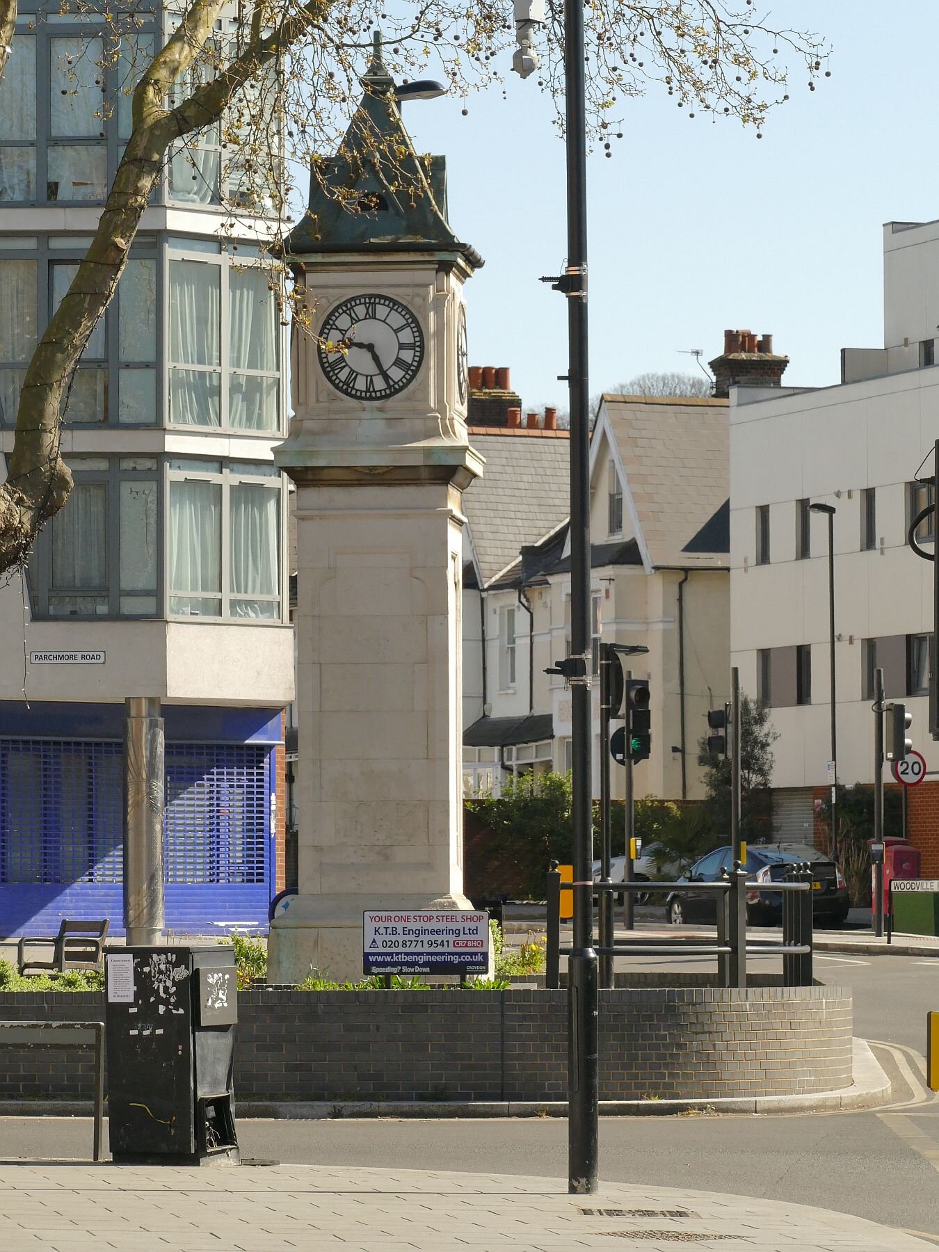
Left: the Thorton Heath Clock Tower
Below: one of the Croydon Stones


After this sedate history lesson, things really began to hot up as we rounded the corner and moved onto the High Street. It was a blast - first the murals, then the building facades, and then the shops themsleves.


We turned off up a side road, to see what went on behind the behind the High Street and were taken aback - again - by the extraordinary contrast offered by the suburban streets. How could anywhere so close to that vibrant, brightly coloured and noisy high street be so quiet and so calm. We could hear the birds singing and we couldn’t hear the traffic. How is it done?
We walked up hill, discussing how we would like to live here, as long as there was a park or open space nearby. As if by magic, we came across the entrance to Grangewood Park. As we entered, the magic did rub off a little, however, as the steep gradient put paid to our day-dreams of spending our twilight years here. If any octogenarians were to make it their daily walk, they would certainly be very fit. Grangewood Park is a relic of a much older estate which was originally part of, guess what? the Great North Wood (https://www.thorntonheathchronicle.co.uk/wp-content/uploads/2020/04/Grangewood-Booklet-v6.pdf). Today the southern lodge is boarded up, the scattered trees look tired (and what is that tent doing in the second picture from the left?), the ground flora is trampled down and the soil looks heavily compacted. Spring seems a little far away, although a Monkey Puzzle tree and some sparkling new gym equipment do lift the spirits.


We zig-zagged back through more amazingly peaceful - and clean - streets, spotting our favourite bits of suburban architecture.


Back on the High Street, we had to face up to the big question. Why were there so many fish shops? We don’t mean fish and chip shops or fish restaurants, we mean wet fish shops, fishmongers, shops that sell fresh fish. Some just sold fish, some sold fish and a variety of groceries or vegetables. We wouldn’t have been surprised if the newsagents had had a fish counter. Why is Thornton Heath fish heaven? If you know please put a comment at the bottom of this blog.
Talking of which, we will postpone the rest of our voyage through Thornton Heath until next week, as there are one or two suprises still to come. But we will leave you with an image of that evening’s supper. It was by far the best fish we have had in ages.
