Another Offa
Nearly a year ago, in the days when we thought Christmas 2020 would happen, we posted a couple of blogs on the Offa’s Dyke National Trail, which we had been section walking since 2015. After two episodes (which included passing the Trail’s half way mark), we decided to give you all a break, and moved on to other topics, but we feel the time has come to revisit the Welsh border lands and pick up the threads of our story once again.
We left you (Blog 6 on 3rd December 2020) with camera failure somewhere near the Breidden Hills. We had walked through the Royal Forestry Society’s Leighton Estate, south east of Welshpool, climbed the long slope to Beacon Ring Hill Fort, shrouded in trees, and then slid down over a thousand feet (342 m to be exact), to the Severn Valley below, crossing the swollen but sluggish river at the grade II listed Buttington Bridge, a mere 68 ft (21 m) above sea level. The Trail then appears to take leave of its senses and threads its way, perilously, through a busy, industrial scale dairy operation. Thankfully, the Breiddens, topping out at a similar height to Beacon Ring make an arresting back drop to both the tankers and the Severn’s lazy journeyings.


The Severn-side section of the trail has been diverted since our antediluvian guide was written and, presumably because of flood risk and the current lack of a Noah’s ark, the way now takes walkers along a short stretch of the Montgomery Canal, which hugs the very western edge of the Severn flood plain, following the contours just below the 80 m mark (262 ft).

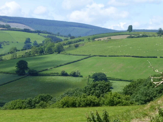
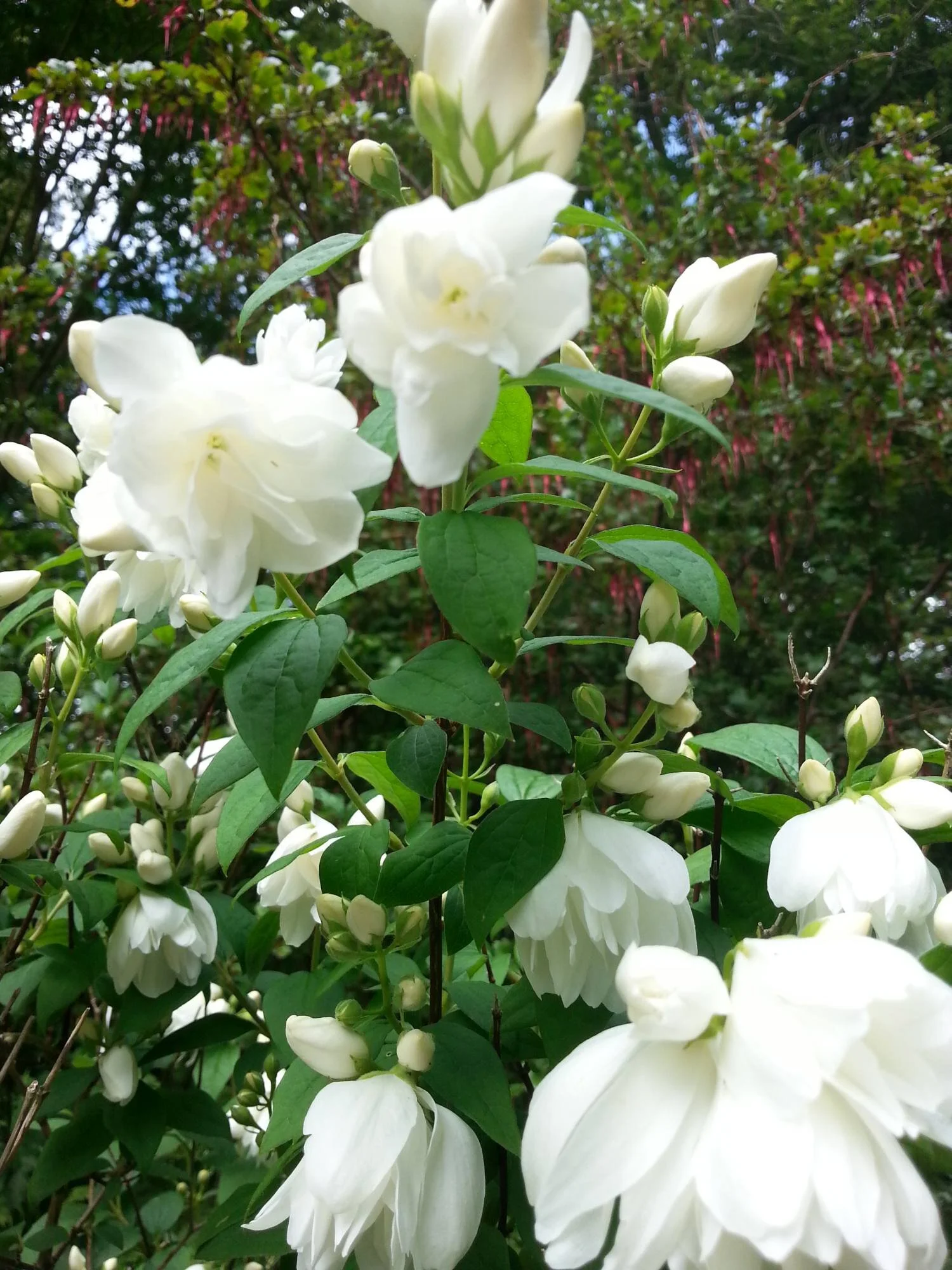
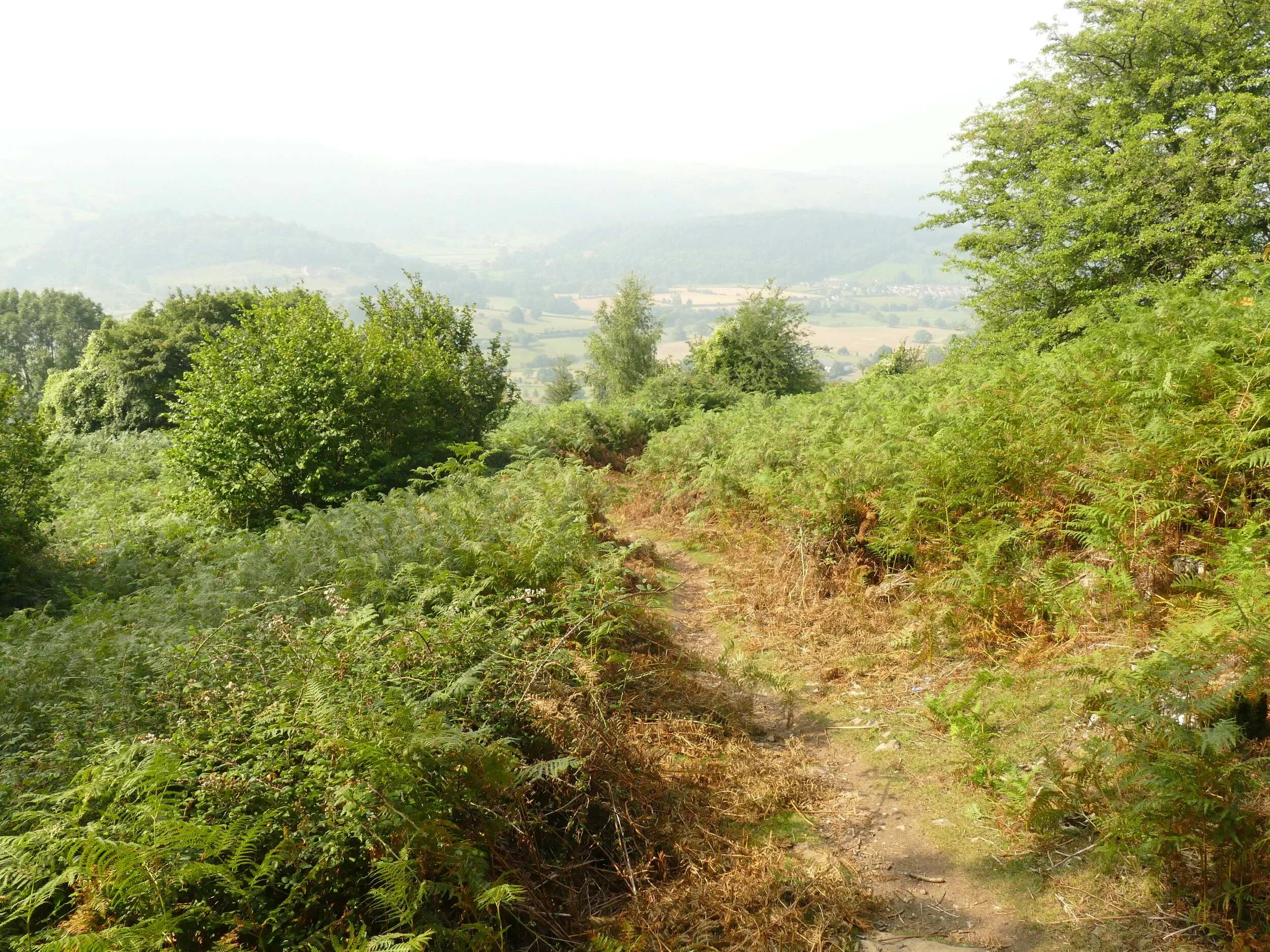
Leaving the canal, the Trail climbs onto substantial flood defence dykes which skirt the Severn’s convoluted meanders. Most such structures are stark, grassy banks within wet pastures,
but this delightful example (image right)
protects a garden, which the owner has allowed, or encouraged, to spill out onto the
Dyke itself.
Eventually, walkers are dumped back down onto the route of Offa’s (much straighter) Dyke, allowing us to tramp through Four Crosses, return to the canal, and move on towards the village of Llanymynech.
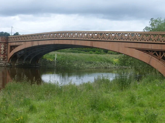
Below: upper row - ornamental tile work in the Four Crosses A483 underpass (see central tile for a historic view of the scary dairy/creamer). Lower row: another sort of traffic node - the Montgomery Canal and the Offas Dyke Trail crossing the River Severn with the help of a, rather grumpy, canal and railway company


Geographically, Llanymynech perches between the Severn valley to its south and limestone hills to the north and is remarkable for being a village half in England and half in Wales. Perhaps unsurprisingly, the village sits on a crossroads (road and, historically, waterways and railway), and provides a bridging point close to where the Severn flows from Wales into England. We cannot comment on Llanymynech’s other significant features as the Trail neatly bypasses it, and throws us staight up Llanymynech Hill and onto the ‘Oswestry Uplands’.
Llanymynch Hill and neighbouring Nantmawr are classics of limestone eminences. Prehistoric remnants – hill forts and the dyke itself – now cohabit with industrial archaeology, created to feed industry and commerce, possibly dating back to Roman times. These steep, irregular uplands, supporting grasslands and small native woodlands, are also pockmarked with (and occasionally devastated by) old quarries, lime kilns and other massive stuctures, and support a complex of old railway lines and cart tracks. Today, these extraordinary landscapes are much used by walkers, support nature reserves and enable us all to appreciate the locality’s industrial and prehistoric heritage.
Below: upper row - industrial archeology/biodiversity. Lower row: steep, irregular uplands


Our beloved if antique guide book (Offa’s Dyke Path, John B Jones, published in 1976 for the then Countryside Commission), notes ‘improved landscape’ as one progresses northward!

By the time you arrive on a level with Oswestry, if feels like the sunlit uplands, with bold sweeps of grass and heathlands around Baker’s Hill and the ‘recreational archaeology’ of the former Oswestry Race Course.


The path then took us on past Selattyn Hill, where major forestry work was taking place (see below - this was in 2019, so the scene may look rather different now), and continues through Craignant village to descend into the Ceiriog Valley and the spectacular views of Chirk Castle, on the other side.


But we have a confession to make. Our section walk for the summer of 2019 ended at Craignant and we didn’t return to make that descent from upland to vale until a miserable January day in 2020. With family, we walked from Craignant, past what John B Jones tells us is the last continuous section of actual Dyke which the Trail encounters, crossed the Ceiriog river at Castle Mill, and attempted a traverse across the Chirk Castle Estate. Due to foul weather – heavy rain and high winds - this normally benign and extensive National Trust parkland had turned into a danger zone, as the wind buffeted the massive and mature parkland trees. We were tempted to ignore the ‘keep out’ signs but finally relented and went the long way around, reaching our destination - the Vale of Llangollen, the Shropshire Union Canal and the village of Froncysyllte - damp, windblown and more than ready for refreshment.
As you can imagine, photo opportunities were limited, and the Terroir photographer was very reluctant to expose the camera to the elements, although the deputy photographer managed to snap a couple of pictures to demonstrate the conditions. So, once again, we are forced to apologise for the lack of any photographic record, in this case, of the Ceiriog valley and Chirk Castle.


In next week’s blog, however, we will return to Froncysyllte, bathed in 2020’s sunshine. We look forward to seeing you there.
More on Offa
Blogging about Offa’s Dyke path has brought home an obvious truth: long distance foot paths are, well, long. Last week, we covered less than half of the Way from Chepstow to Prestatyn. In Terroir’s terms, this is about a year and a half’s worth of section walking. This week, we return - it’s now 2017 - to pick up the baton at the foot of the Black Mountains, moving from Monmouthshire to Powys with some forays in and out of Herefordshire and Shropshire.
I realise that these blog accounts bear no resemblence to a traditional guide book, and are distinctly lacking in wayside commentary or historic detail. But that is rather point. I have read detailed and wordy blogs on long distance footpaths and, as with the guide book, they have little to say that is memorable if you are not walking the Way as you read them. All Terroir is attempting is to sum up the essence of the trail in a few pictures and fewer words. Inspiring? Good. Boring? Go buy a Guide Book!
Hay on Wye to Knighton - sliding down into Hay from the Black Mountains, we promptly took a day off to explore the town and, of course the book shops. Hay doesn’t grip us. Maybe it needs a festival… But what happens next more than compensates. Next is forgotten Radnorshire, a tapestry of exceptional countryside, with extraordinary towns. Our ancient guide book (John Jones’s ‘Offa’s Dyke Path’, HMSO for the Countryside Commission [remember them?], 1976) speaks of ‘broken hill country’ and ‘the most strenous walking on the Offa’s Dyke Path’. Don’t believe it - the seamless weave of hills and valleys urges you on, begging you to walk to the crest, rewarding you with bizarre surprises, textured and tempting views, and a way down again which enticies with promises of further delights. The diary of the Rev Francis Kilvert, whose ‘country’ this is, also beckons, with lyrical and accessible prose and a historical perspective which makes one weep for lost diversity: ‘Went to Bronith [Bronydd]. People at work in the orchard gathering up the windfall apples for early cider. The smell of the apples very strong. Beyond the orchard the lone aspen was rustling loud and mournfully a lament for the departure of summer’ (Kilvert’s Diary 1870 - 1879, Penguin Books 1987).


We stray off piste, of course. Hergest Croft garden on the way down the long grassy slope from Hergest Ridge is a must (see below). Kington, the sort of a town which supports two butchers where others have none, is described in our guide as ‘not the pleasantest town on the long-distance path’. I hope it gets a better press in the more up to date editions; entering Kington is like walking back into the 1950s and an experience not to be missed. Knighton seemed much more up to date and very much aware of its responsibilities as the ‘capital’ of the Dyke, providing all sorts of useful services to walkers and interested visitors alike.


The Clun Hills - we are in England, perhaps due to aspirational Marcher Lords attempting to push the boundaries forever westwards. The river Clun is the theme, prompting the latter day Marches’ enthusiast, A E Housman, to pen the following: ”
“Clunton and Clunbury,
Clungunford and Clun,
Are the quietest places
Under the sun.
In valleys of springs of rivers,
By Ony and Teme and Clun,
The country for easy livers,
The quietest under the sun,
We still had sorrows to lighten,
One could not be always glad,
And lads knew trouble at Knighton
When I was a Knighton lad.”
It goes on for another four verses but the depression which reading Houseman always induces in me is beginning to become unbearable. Look it up if you want more! The Clun Hills are subtly different from the Radnorshire variety. Here, old Red Sandstone and Dolerite give a rougher, more irregular feel; there is more woodland, scrub and hedge, pasture rather than meadow. It is exhilirating, spooky, varied - and you get to Dyke’s half way point.


Back to the Severn and the Vale of Montgomery - we are coming down off the hills, through woodland and onto the Severn plain, another almost violent change in landscape. There will be hills and views later but the immediate contrast is, literally, a bit of a let down. The Wye is sluggish, recovering from a spate of flooding; silty hedgerows bear witness to recent high water levels. The ground is damp, stolid, riparian, but an unexpected garden bordering the dyke provides domesticity, diversity, delight - and cake. A section of road walking contibutes another downer but suddenly the contours begind to wriggle and twitch and we find ourselves creeping up the ‘foothills’ of the Long Mountain, past the heroic remnants of an an abandoned quarry. Here on the Long Mounain lies ‘Leighton’, originally part of the estate of the same name but donated to the Royal Forestry Soceity (RFS) in 1957. Leighton has many claims to fame, particularly an old grove of Coastal Redwoods, planted in 1857, very shortly after the first specimens were intrduced into Brtiain. They remain unthinned, as requested in the gift, but a 1934 planting is managed by the RFS for timber and for an element of biodivesrity, to support the ‘wide range of plant species and associated insect life [which] … flourish’ in the estate. https://www.rfs.org.uk/media/28903/leighton-info-for-visitors.pdf The Way curves around elaborate dams and ponds (old water management features) and through shade cast by the most ecletic mix of native and exotic species I have seen in some time.
And now the confession. Our pictures of Leighton vanished in a mysterious digital crash, no doubt engineered by the sprites of the Long Mountain, and the heavy shade cast in many areas. So yet another reason for a visit to Offas’s Dyke.


So, as the Long Mountain fairies wreck our sign off at Leighton and the neighburing hill, The Breidden, we will leave you to seek accommodation in Welshpool or Oswestry, or perhaps take a turn in the neighbouring shooting estate, before continuing this journey to Llanymynech, Llandegla and the Vale of Llangollen.
Breaking News
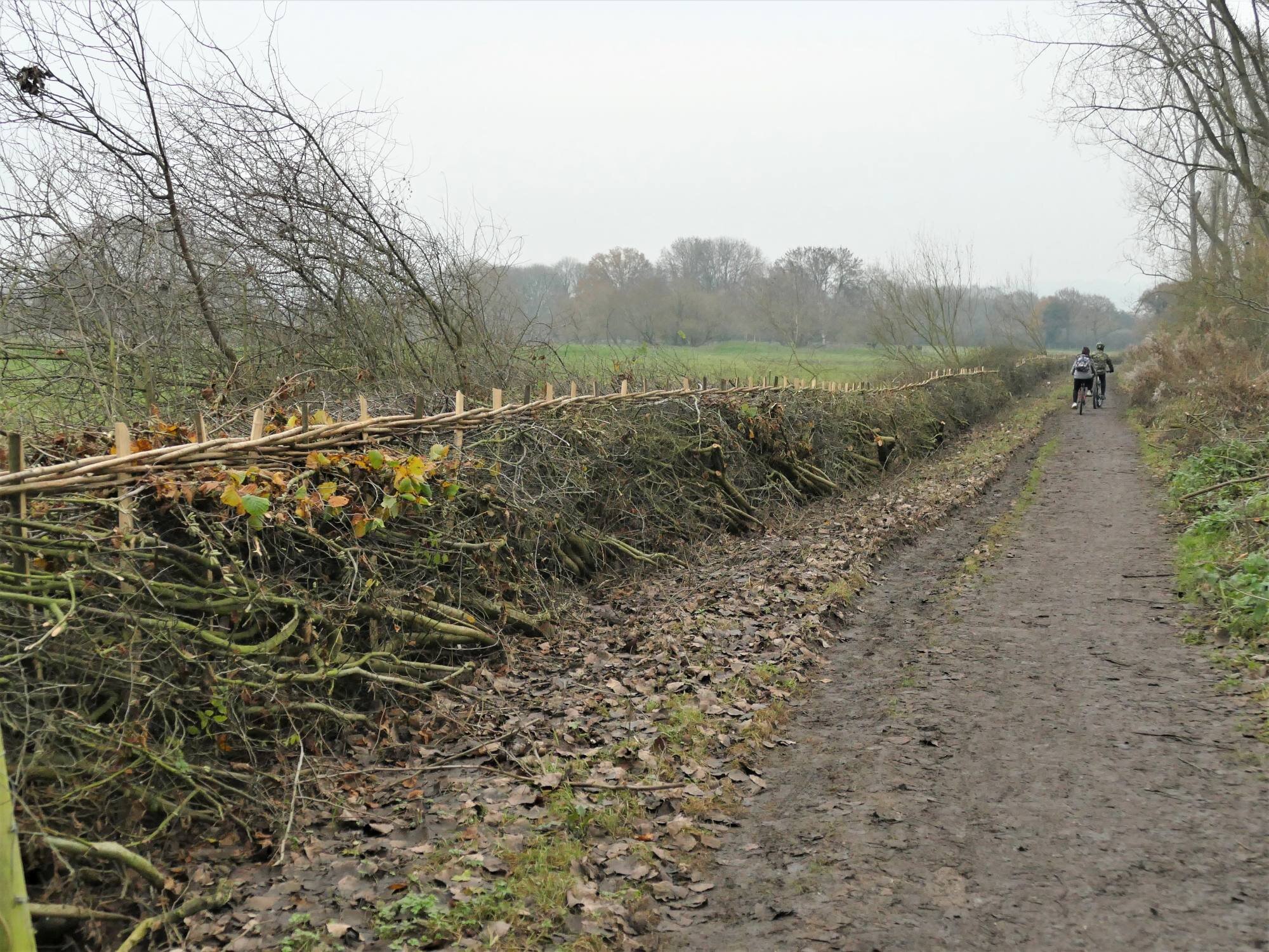
Remember the hedgerow which failed to thrill me in Blog 1? Three cheers for the Surrey Wildlife Trust ( https://www.surreywildlifetrust.org/ ) who have transformed part of the hedge into a heritage and wildlife beauty.