
River Hacks
A blog on rivers is a bit like trying to eat an elephant – where do you start? Every day there is news of more sewage being pumped into our rivers, of pollution from agricultural residues, highway run off or illegal dumping (from old mattresses to plastic bottles and unwanted chemicals), of rivers flooding or drying up and of drastic reductions in river and wetland biodiversity.
Water has been crucial to life since life began. Rivers, in particular, have been of primary importance to humankind: water to drink, for food production, sewage removal, power generation and transport are just a few of their benefits. Rivers, as opposed to ponds and lakes, flow, so that whatever you chuck in ‘disappears’ downstream. Heaven help you if you are a downstream community.
So, as with eating the proverbial elephant, Terroir is going to tackle the topic of rivers just a little bit at a time. Today we’ll take a brief look at flooding. Please don’t ask which bit of the pachyderm this subject symbolises.
Flooding is usually defined as the inundation of land that is usually dry. This simple definition ignores, however, the cultural reaction to ‘flooding’ and to the definition of ‘usually’. In towns, flooding is regarded as alien, fearful and, until recently, a fairly unusual phenomenon. It also inspires anger, that ‘somebody’ allowed this to happen - again - to our town/village/road/footpath etc etc. Yet we still build and buy houses located in a flood plain.
In contrast, farmers have long used flood plains or marshland for grazing. Perhaps ‘usually’ in this case means land which is dry (or dry-ish) for longer than it’s wet (or very wet) which, combined with seasonal knowledge (wetter in winter than summer) and appropriate agriculture (stock rearing) means that temporary inundation is a very useful and positive phenomenon.
Going a step further, let’s look at the concept of ‘water meadows’. Constable loved painting them – all those pollarded willows and romantic cattle set in a lush, bucolic landscape. The Historic England publication, ‘Conserving Historic Water Meadows’ (July 2014) describes water meadows as ‘areas of land that used to be flooded deliberately, under carefully controlled conditions, the timing being at the discretion of the farmer or landowner. They had three main purposes: to force early growth of grass in the spring, to improve the quality of the grass sward and to increase the summer hay crop. Here is society actively encouraging flooding, with sufficient technology and knowhow to make a success of it. [Terroirs highlighting]


Above left: exciting, wild, primeval, a natural phenomenon? © Christine, ref below
Above right: scary, damaging, expensive, someone else’s fault?
So Terroir’s definition of flooding for the 21st century is something which happens when more water flows into a river than the river system and society can cope with. I imagine that prehistoric society adapted quite quickly to this sort of thing. It probably didn’t take too long for sedentary communities to work out that building too close to the water’s edge was distinctly risky. Something which we seem to have forgotten.
Which brings us to flood and risk management: Terroir sees this as creating a balance between greed and disaster. Greed can be as simple as building too close to water course, or straightening and canalising a river to create more ‘usable’ land, thus giving storm water nowhere to go except into your house. On the other hand, London recognised that the cost implications of the Thames overflowing its banks, not to mention potential loss of life, were so enormous that money was spent on creating flood barriers.
The Thames Flood Act of 1879 was introduced to build higher and better river walls along the Thames and these walls have been rising ever since. The Thames flood of 1928 overtopped the then current walls and 14 people died and thousands were made homeless. Anyone living in a basement flat would have been particularly vulnerable and these were often the abodes of the less well off.


Above left: Thames flood walls on duty at the Houses of Parliament
Above right: clearly illustrating the business of building higher, these walls form the riverside boundary of Victoria Tower Gardens, Westminster

Of course, the more you build, the more you have to maintain. One small breach in the wall can lead to catastrophic effects. Sir Thomas Frank was knighted, in 1942, for his organisation of rapid repair teams to retain the integrity of the Thames flood walls during the Blitz.
The 1953 flooding of eastern England impacted a far wider area, including the Thames estuary and parts of London itself. As a result, serious thought was given to alternative flood control.
The Thames Barrier and Flood Prevention Act was passed in 1972 and the Barrier was finally operational in the early 1980s. It was expected to operate in earnest about once or twice a year. This figure has since risen to 6 to 7 times a year, on average, but this statistic disguises some extraordinary peaks in three extraordinary seasons: 2000/01 (24 closures), 2002/03 (20 closures) and – wait for it – 50 closures in 2013/14. https://www.gov.uk/guidance/the-thames-barrier#thames-barrier-closures


So what’s going on? There are a whole host of factors involved – a selection is listed below - and when they combine the results can be catastrophic.
Sudden thaws creating high volumes of melt water (yes even in the UK!)
Increase in rainfall and increase in significant heavy rain storms which create runoff beyond the short term capacity of the drainage system
Increase in hard surfaces in urban areas and corresponding decrease in permeable areas such as gardens and verges, playing fields etc etc
In estuaries, high tides and storm surges such as created the 1953 floods in the UK
Canalising rivers and destroying the natural flood water holding capacity of a river valley
And, of course, climate change, not just changing rainfall patterns but raising sea levels.
In Terroir’s view, one of the cheapest and most attractive methods of improving flood resilience in urban areas, is the construction of rain gardens. These areas go some way to compensate for the loss of permeable areas in towns and cities, absorbing water and slowing down the run off to the river. They come with massive added benefits as well, creating a series of spaces for city dwellers and wild life alike. As linear gardens, they provide year round, urban oases with places to sit, to walk, to jog, to eat lunch, to meet a mate, to watch the butterflies or the dragon flies, all in the knowledge that they are not only reducing flood risk and water pollution, but also enriching the local environment in many other ways.
Here are two of Terroir’s favourites.
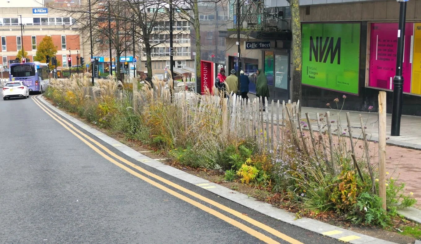
Sheffield ‘Grey to Green’

Sheffield is over familiar with urban flooding. With its two rivers – the Don and the Sheaff – and a large, hilly urban area which feeds water downhill fast, the city watches water levels carefully.
To be honest, the two flood levels shown on this Kelham Island pub are a tad misleading as the 1864 flood was caused by a reservoir dam collapsing some 8 miles upstream of Sheffield, but the lower line is 21st century - 2007 - and quite scary enough, thank you.
Many places flooded in 2007, but Sheffield was particularly badly hit. As it happened, the construction of Sheffield’s Inner Relief Road was completed the following year leaving a significant amount of redundant road surface.

Thanks to some blue sky thinking (sorry couldn’t resist that one), much of this impervious ‘grey’ was converted into ‘green’ water gardens. Planting was designed by members of Sheffield University’s innovative Department of Landscape. The plant palette is robust, low maintenance and undemanding, but never dull.


It is terrible jargon, but yes, we do need to ‘roll this out’ everywhere.