Still Tumbling In

In 1919, the church of All Saints (the last remnant of the Suffolk coastal city of Dunwich), finally fell into the sea. Dunwich probably started as a Roman fort, became a Saxon settlement and, by 1086, was one of the ten largest towns or cities in England, despite having already lost a significant acreage to coastal erosion (http://www.dunwich.org.uk/history/). Major storms continued to eat away at the coast line such that, by 1602, the city was reduced to around a quarter of its former size. Storms in 1740 flattened what was left, leaving only the church to survive into the 20th century.
Image right: Dunwich Beach in June 2009 © ADE46 (link at end of blog post)
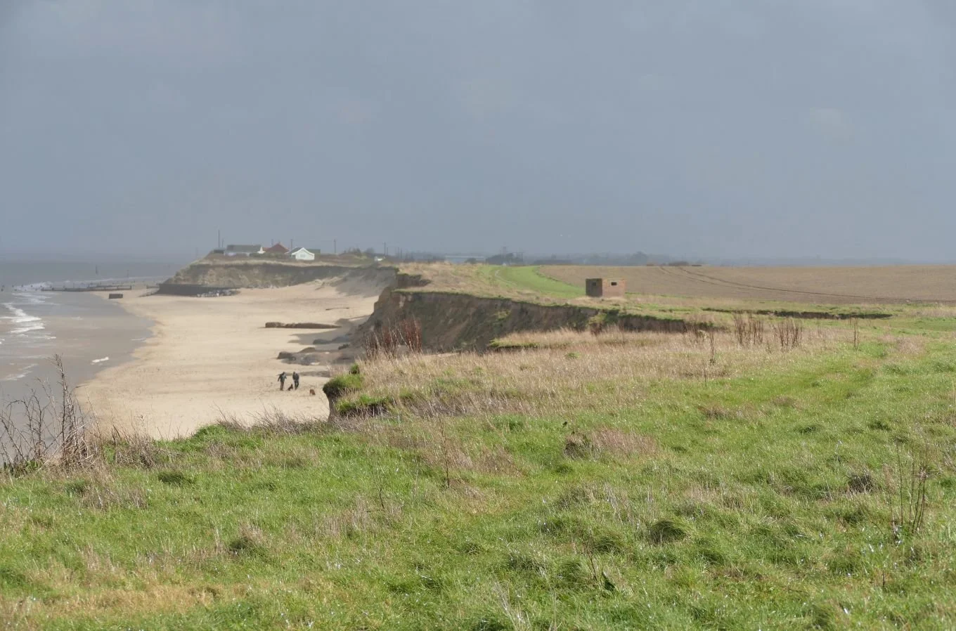
Further north on the East Anglian coast lies the star of our previous post: the village of Happisburgh (pronounced Hazeborough, of course). Around 50 miles up the coast from the lost city of Dunwich (pronounced Dunnidge), Happisburgh is described as the ‘Village Falling into the Sea’. Coastal erosion is, once again, the culprit. The present tense is still applicable to Happisbugh, but for how much longer will this be the case?
Image right: Happisburgh beach backed by those crumbling cliffs
Happisburgh, it seems, was never of the size or substance of Dunwich. But appearances can be deceptive, and human activity left its mark on the area long, long before the Romans ever eyeballed its Suffolk neighbour as a site for a coastal fort. It’s hard to get your head around the archaeological and geological history of the area, but it seems to go something like this:
It’s the early Pleistocene – maybe 2 million years ago and the ‘Ancestral’ River Thames probably rises in or around Wales and flows to the sea in the Happisburgh area. The Solent, the Seine and the Somme all seem to be in fairly familiar positions but, shock horror, the British land mass is part of the European continent, joined at the hip from, say Portsmouth to north Suffolk.
It’s getting chilly. Ice ages are rolling in. Ice diverts the Thames southwards (think Vale of St Albans, Richmond, Walthamstow and finally all points east). Pesky glaciers dump glacial till in the Happisburgh area. Fast forward to maybe 800,000 years ago and human-like figures are roaming East Anglia, dropping axes and who knows what other bits and bobs. We’ll come back to that later.
Forward again, into historical times. That soft East Anglian geology is now on the coast of an enlarged North Sea. Britain has become the British Isles. The shoreline is littered with crumbling cliffs, and coastal erosion becomes a physical reality. Communities build or farm close to the coastline and, whoa, suddenly, coastal erosion has become, not just a physical phenomenon, but a social, economic, political and frightening ‘thing’.
So where does that leave Happisburgh now? It leaves the village, where it has been for centuries: erratically and irregularly ‘Tumbling in’ to the sea. The village website (http://happisburgh.org.uk/history/sea/coastal-erosion/) provides sobering evidence. The neighbouring parish of Whimpwell had vanished completely by 1183. 19th century evidence for Happisburgh records a newly drilled field of wheat disappearing overnight (1845); Whites’ 1854 Directory suggests a coastline retreat of 250 yards in the previous 70 years; a set of farm buildings goes over the edge in 1855. The epic storm of 1953 caused unimaginable damage with 7 fatalities and horror stories such as “A bungalow … which at teatime on Saturday stood 15 feet from the cliff, was hanging over the cliff edge on Sunday morning”. There is more and it is uncomfortable reading.

The map evidence is equally dramatic. The image, left, shows Happisburgh in 1885. Note the square of roads which used to link the Coastguard Station, the Hill Hotel and the village centre before turning south and then east to complete the circuit and link with the coast road to the Low Lighthouse (located at the bottom right of the image). The north east corner of the road square has already gone over the cliff edge and the lighthouse, now also at risk from erosion, is recorded as having been closed in 1883.

In the 1930s, a ribbon development of cliff top dwellings has been constructed, despite the fact that the north east corner of our square of village roads has tumbled even further into the sea.

A mere twenty years later, some of these houses have aleady gone (the writing no longer on the wall, but on the beach?) but the coast road still appears to be functioning.
Map images all © and reproduced with the permission of the National Library of Scotland https://maps.nls.uk/index.html
Today, all the houses as well as the coast road have gone and a more westerly track which has replaced the road is already close to succumbing to the same fate. The process is clearly illustrated by the following images of active coatal erosion, all taken in March 2023.


Attempting to secure or protect the coast is costly and/or short term. ‘Hard’ reinforcements, such as groynes, energy absorbing rock barriers or concrete defences merely move the problem further up or down the coast, and require constant and expensive maintenance. Soft solutions such as ‘sandscaping’ or ‘nourishing’ the beach with sand have been tried, for instance on the coast between the Bacton Gas Terminal and Walcott, a few miles north of Happisburgh. Fuel security has obviously been the key to this scheme but Terroir suspects the works are too recent to provide significant results or reassurances. https://www.north-norfolk.gov.uk/sandscaping#:~:text=The%20Sandscaping%20scheme%20is%20based%20on%20a%20Dutch,erosion%20and%20flood%20protection%20to%20Bacton%20and%20Walcott
Hard defences have been constructed on Happisburgh Beach. Groynes were built in the 1950s. Part of a wooden beach revetment to the south of the village was washed away in 1990; the subsequent rate of erosion is said to have increased.


On the cliff top to the south of the Low Lighthouse site there is another row of homes or holiday cottages, some of which still survive. On the beach below is a stretch of concrete and rock armour, begun in 2002, presumably to buy time to allow for appropriate planning before ‘managed realignment’ allows the inevitable to happen.


But island Britain cannot afford to defend any more than a tiny proportion of its eroding coastline. In the past, the economic value which could be attributed to the works was probably more important than the emotional or financial needs of residents about to lose their homes. Today, managed realignment, coastal adaptation, improving coastal resilience are catch phrases of the moment, but if your house is perched perilously close to a rapidly moving cliff edge, this may not be much comfort. Also there is no single approved process for compensating for the loss of private property or land caused by coastal erosion in England. Schemes of compensation appear to be very variable in terms of approach, scope and financial aid.
Coincidentally, a BBC Radio 4 episode of ‘Costing the Earth’ was broadcast on April 18th, soon after Terroir’s visit to Happisburgh. Entitled ‘Losing our History’ (you can listen to it on BBC Sounds) the broadcast looked at the impact of coastal erosion in three very different parts of the world – Ghana, Bangladesh and – yes – Happisburgh. Specifically, the programme asks if we all need to prepare for the emotional impact of climate change, and calls for the inclusion of the community and of local skills and knowledge in planning the managed retreat process. Well done to ‘Costing the Earth’ for championing these aspects of managing coastal erosion and to the BBC website, which has some exceptionally moving eye witness accounts of the Happisburgh experience.
https://www.bbc.co.uk/news/uk-england-norfolk-63822899

But Terroir wishes to end this blog on a more cheerful note by looking at something positive which can result from coastal erosion. Remember those lost pick axes and wandering figures who were strolling about during the Pleistocene? Coastal erosion can undermine houses, fields and livelihoods, but it can also reveal surfaces which may have been buried beneath glacial deposits for thousands of years.
In 2000, a dog walker (that may be apocryphal) found a flint axe head in muddy sediments under the sands of Happisburgh beach. There seems to have been some debate on its age: 100,000 years old? 200,000 years old?
But this was just the warm up act. In May 2013 the Happisburgh Footprints were revealed: hominid prints embedded in newly uncovered sediment, and partially covered by beach sand. Lying below the high tide mark, tidal erosion could reveal but also destroy, but thankfully they were photographed and recorded before the prints were washed away - in less than two weeks. The footprints revealed a family group of perhaps five people, walking upstream on the mudflats of the Ancestral Thames estuary.
The following year, the footprints had been dated to perhaps a massive 800,000 years ago, making then the earliest known human type footprints to be found outside of Africa. The axe head has since been re-dated to a similar period.


Wikipedia (https://en.wikipedia.org/wiki/Happisburgh_footprints) suggests coastal erosion has been revealing new material at Happisburgh since at least the 1820s and knowledge of the environment of this early family seems to be increasing all the time. Sometimes coastal erosion gives, as well as takes away.
Ade46 link: https://www.flickr.com/photos/ade46/3642316814/in/photolist-6xRPTL-6xME9V-coPuSU-fejf1H-z5QhAV-59LQ7F-T6TRjW-WeBRzK-iVorx-2nQBKMV-59LTRF-YgW5o-2tXhZg-YgWGS-2tXhYK-2tXhYx-xdYdxM-4avYrS-2nRqSuc-54NSgE-4arKeR-6xRMXC-Ee7J9-fh4kwv-tgwewo-2tXhZK-fh4krD-fdBDkL-2bA5goF-2bA5feg-fdBC6L-2bA5gY8-2bA5gG6-gWEy2i-2on7LSs-9d8Gxx-2nRxqTv-4arvAV-2bA5fJ4-4arTNt-2mhan11-4avzoE-2bA5fYx-4fUVai-zqWDnj-4arHwP-4aw3js-54NSwE-oJhhHs-26nq5xm