Can it be a fair COP?

This blog premiered last year with a visit to ‘The Moors’, and we make no apology for having re-visited on a roughly quarterly basis. A wetland, urban nature reserve in north east Surrey, the Moors is a marvellous example of what humans and the planet need, to remain healthy and low carbon.
With the recent publication of the latest International Panel on Climate Change (IPCC) report one hopes that the whole world is reading and thinking about just that - climate change. One also hopes that the contents of the report will be fed into national government policies around the planet, with lots of trickle down impacts to deliver action right at the roots of local communities. Hope is cheap. Action is not. Riches are unequally distributed.
The IPCC was set up in 1988 by the World Meteorological Organization and the United Nations Environment Programme. ‘The objective of the IPCC is to provide governments at all levels with scientific information that they can use to develop climate policies. IPCC reports are also a key input into international climate change negotiations.’ (https://www.ipcc.ch/about/).

The Panel’s latest report, published earlier this month, is entitled ‘Climate Change 2021, The Physical Science Basis’. The title sounds a bit like an advertisement for hair products, but just skimming through makes for a heavy and uncomfortable read, although it is not totally without hope. Below are a few key headlines, although you have probably already heard them via the press and media.
“It is unequivocal that human influence has warmed the atmosphere, ocean and land.
Widespread and rapid changes in the atmosphere, ocean, cryosphere and biosphere
have occurred.”
“Human-induced climate change is already affecting many weather and climate extremes
in every region across the globe. Evidence of observed changes in extremes such as
heatwaves, heavy precipitation, droughts, and tropical cyclones, and, in particular, their
attribution to human influence, has strengthened.”
“Many changes due to past and future greenhouse gas emissions are irreversible for
centuries to millennia, especially changes in the ocean, ice sheets and global sea level.”
But
“Scenarios with very low or low GHG emissions … lead within years to discernible effects on greenhouse gas and aerosol concentrations, and air quality …”
https://www.ipcc.ch/report/ar6/wg1/downloads/report/IPCC_AR6_WGI_SPM.pdf
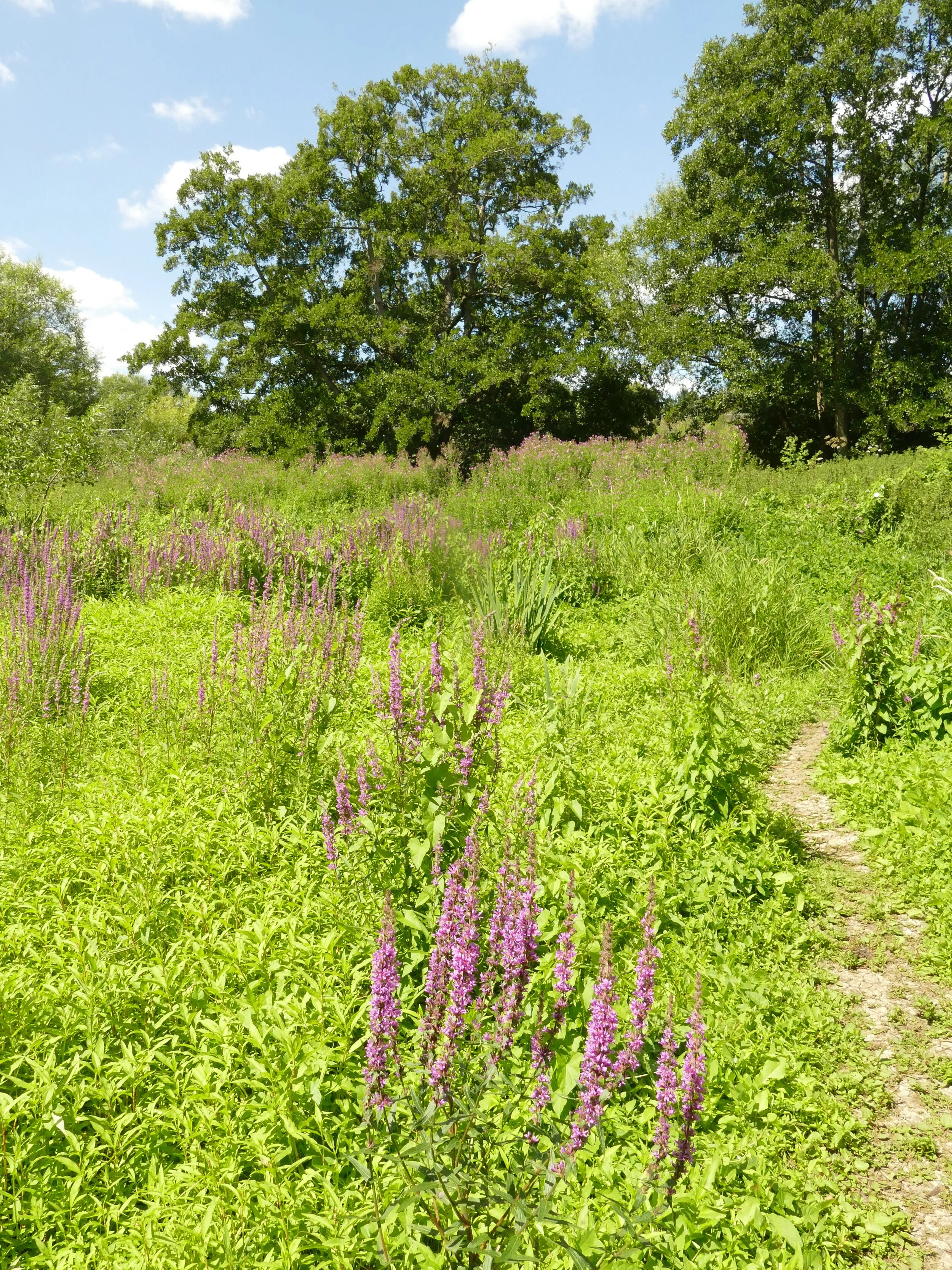
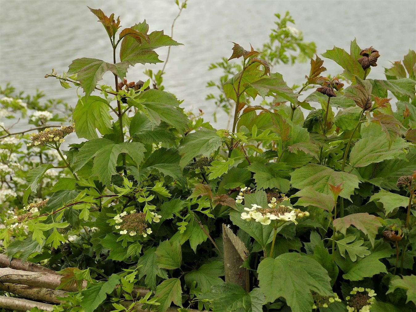
Looking at the Moors, trying to think globally and act locally, it is depressing how very obvious climate extremes have become. In 2020, we had a prolonged spell of very warm and dry weather. The wildflowers bloomed profusely and provided massed stands of vibrant colour.
This year, as noted in Blog 31 (The Darling Buds), spring was late and, apart from a brief dry spell, rain has been exceptionally plentiful. Growth has been lush and massive - huge leaves, oversized trees - and the overwhelming palette of The Moors has been very, very green. Now, in August, as we shiver in our pullovers while drying sodden umbrellas, the greens are still the dominant hue. Spring’s hint of white has been replaced by over-tones of yellow, blue and red, but the contrast with last year is still remarkable.
2020’s vibrant stands of tufted vetch are now battered and tired, the common agrimony and willow herbs are isolated and low key, and the latter (below right) weighed down by a flourishing growth of black bryony.


The ragwort continues to flourish but its normally ubiquitous companion, the cinnebar moth caterpillar, is notable by its absence. By this time last year the teasels had strutted their stuff and where dry and brown. This year they are only just getting to their peak.


Climate change does not necessarily mean plant extinction but may mean plant migration. At somewhere like The Moors, species which have not done well in 2021, may have a chance to return next year. Meanwhile other species, such as buddelia and water mint, have done better in the wet weather, and species which are much more unusual may appear, such as marsh woundwort (in this case, struggling with another vigorous black bryony) and chicory.


The sheer mass of growth has also changed the character of The Moors this year. Where paths are lined by trees, the canopy is thick and has already developed the dark green foliage of late summer. Shading has kept the cycle path remarkably open. Enchanters’ Nightshade has crept to enjoy the shadows and stinging nettles are thriving on the now damp areas of richer soils. Nearer the brook, and on a windy day, the vastly expanded willows do an excellent imitation of a William Morris wall paper. Between the lakes, where no tree has much of a roothold, the path is virtually hidden by the explosion of vegetation. The craft skill of last year’s hedgelaying exercise is now obliterated by substantial new growth.


Summer downpours have proved to be a heady mix at The Moors. The water levels thoughout the wetland are at winter levels, yet the vegetation is responding to summer temperatures and light levels. Although not currently flooded, the wetter areas of the cycle path are as muddy as in winter. All water bodies are full yet the eruption of vegetation growth has hidden the smaller seasonal ponds from view. Woe betide anyone who tries to take a walk through this apparent meadow of purple loosestrife, below right.


The Brook has vanished completely, except for one point where somebody has cleared a narrow track to the bank, as though checking that the stream still exists.


What will COP 26 and climate change 2022 bring?
History Hurts
Sugar and Slate, but some still hate…

If you are lucky enough to be celebrating a wedding in the lush countryside immediately to the east of the university city of Bangor, North Wales, the chances are that you will also be able to see the eccentric towers of Penrhyn Castle peeping over the tree tops of the extensive estate which surrounds it.
The Penrhyn Estate has a long and complex history. It starts with the early 13th century Prince of Gwynedd rewarding loyal supporters (Ednyfed Fychan and his sons) with large tracts of land throughout North Wales. Son Goronwy ab Edyfed received the promontory (or penrhyn in Welsh) east of Bangor and, capitalising on political opportunities and judicious marriages, his early 15th century decendants found themselves in possession of a large estate and fortified manor house.
Fortunes ebbed and flowed but in the second half of the 18th century part of the estate was purchased by John and Henry Pennant, sons of Edward Pennant of Clarenden, in Jamaica. As you can imagine, cash flow improved dramatically on the back of the Pennant’s sugar plantations and their slaves, and the remainder of the estate was rapidly acquired as well. The manor house was remodelled and farming practices, including tree planting and new buidlings to provide shelter, plus drainage and manuring, revolutionised the estate farms. Terroir has yet to find any details of the capital expenditure required to undertake this work, or what impact the improvements had on the tennants’ rent. The Pennants also invested heavily in what came to be known as the enormous Bethesda slate quarry, a few miles south of the Castle. Again, considerable capital investment in infrastructure is recorded but nothing on rates of pay for the quarrymen.

The early 19th century and the financial crisis created by the war with France had not been kind to Caernarfonshire. Pennant money, however, was still plentiful. By now the estate was owned by George Hay Dawkins-Pennant who went on a massive spending spree to create the fantastic, mock Norman castle which dominates the area today. It appears to have been unbelievably splendid.
The fairy tale castle on the outside:


And on the inside:


The death knell was post war (WWII this time) death duties, which saw the Castle and estate pass to the Inland Revenue who transferred it to the National Trust.
But as you may have gathered, this blog isn’t really about the architecture and landscape of Penrhyn Castle, but about the society which the Castle represented over the centuries and what it says to us today.
Along with many other guardians of our heritage, the National Trust is engaging with communities and individuals to acknowledge, understand and interpret the heritage and history of the enslaved communities who created so much wealth for the British Empire and who, unwittingly, contributed to the creation of so many buildings and landscapes which were once the homes and preserves of the few but which are now visited by the many. The panels in the Penrhyn Castle dining room (see photograph above right) are part of one such project and in this example, the English panel reads:
Let’s think beyond the box.
Lock it. Hide it. Shelve it.
Darkness conceals the light which exposes
Questions flowing through the cracks in the corners.


But should we not also be asking about the plight of the working communities of Britain who were also used to create wealth for the very heart of the British Empire? These were not enslaved people, but these were British workers who had few choices or means of embracing an alternative lifestyle.
Looking through the National Trust Guide to Penrhyn Castle, we canot help asking who made the hand knotted Axminster ‘Turkey’ runner which adorned the Keep Passage? Whose skills were honed in Asia and then transferred to Devon and under what circumstances? Could the workers afford fuel for heating or shoes for their children? The original carpet was replaced by a machine woven Axminster in 1987. Was the machinist paid the equivalent of what is now known as the minimum or the living wage?
This issue is particularly relevant to Penrhyn. Remember the Penrhyn Quarry? In 1865, the local quarrymen attempted to form a Union but the movement was quickly nipped in the bud by Lord Penrhyn. By 1874, however, the North Wales Quarrymen’s Union was officially established and, after a short strike, was recognised at Penrhyn Quarry. Relationships deteriorated, however, with a major strike in 1896-7 and a calamitous strike/lock out from 1900 to 1903. As usual, the issues appear to be complex and included falling production, reduced profits, paternalistic attitudes hardening to ‘taking a firm line’ (National Trust Guide Book), Union rights, and workers pay and working conditions. The results were disastrous, ripped the community apart, and created all the ills which only poverty can bring (for further details see https://www.nationaltrust.org.uk/penrhyn-castle/features/penrhyn-castle-and-the-great-penrhyn-quarry-strike-1900-03 and many other websites).
No one who was involved in the strike is left today, but that has not eliminated the impact on the local community. Terroir visited the Castle but, despite the change of ownership, our Welsh companions would not enter a property which represented such terrible damage to the local community. Following further enquiries, we realise that this attitude is still widespread.
‘Hate’ is a strong word, but so is the damage which has so often been inflicted on local communities by landlords and employers and which continues to hurt some 120 years later. Hence Terroir’s reworking of the old ‘sugar and spice’ rhyme.
Sugar and Slate, but some still hate…
How do we heal the wounds?
Designed in Dundee
Watching the re-run of the BBC crime drama ‘Traces’, set in Dundee, sparked an urgent desire in Team Terroir to visit this remarkable city. We had heard about the Dundonian three Js, of course - Jute, Jam and Journalism - but ‘Traces’ also resurrected half-forgotten conversations with English friends who had studied various aspects of design at Dundee University. Dundee and design seemed to have a synergy which warranted exploration.
We were not disappointed. A five day stay in the heart of Dundee left us enthralled, surprised, enlightened, shocked, amused and warmed. A history of fishing, whaling, ship building, linen and jute weaving, marmalade making, polar exploration and journalism seems to have created a community which was tough, adaptable, robust, diverse and responsive both to need and opportunity. We found a city with wide streets, little traffic, busy buses, a tolerant attitude, two universities and a spectacular approach to heritage conservation. Not a bad set of lists for just 120 hours. Every city has its problems of course and we saw some evidence of social issues and, of course, the legacy of making money off the back of the British Empire. But none of that is specific to Dundee.
What follows is a very personal tour of the city, with particular reference to design and quirkiness. Five days is not enough to be objective, thorough or searching, but it is enough to know an enjoyable city break when you see one.
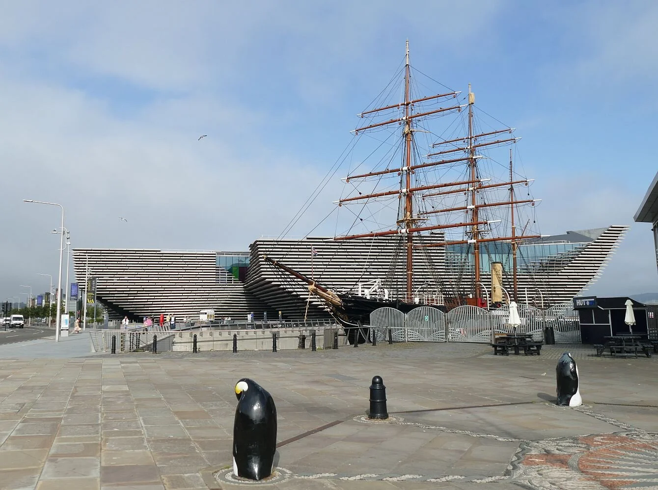
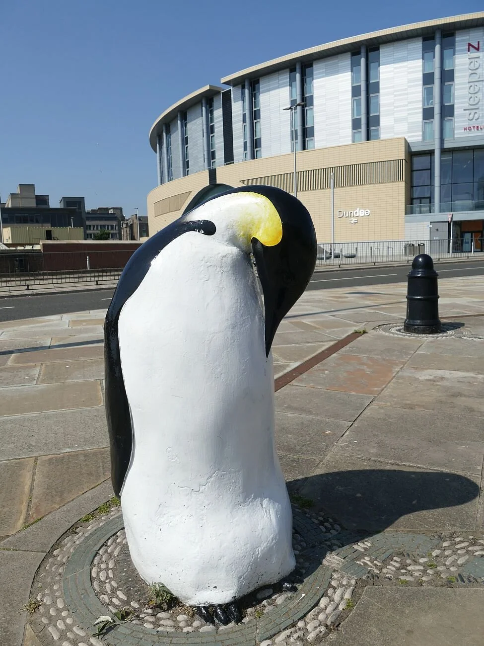
We started at the Dundee V&A. Following an international competition, the building was designed by the Japanese architects Kengo Kuma & Associates. I’m sure Mr Kuma will be delighted to know that Terroir thinks his design works well for its context and location - right on the water front next to Scott’s Antarctic exploration vessel, the Discovery. The ensemble creates a number of open spaces, one infested with penguins, which are perfect for a sunny Covid afternoon, if rather too close to one of Dundee’s few busy roads.

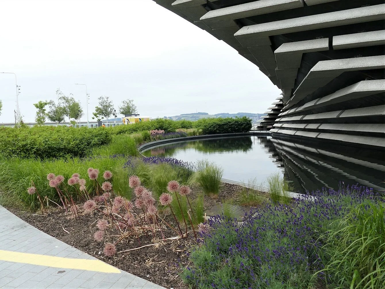

Inside, the ground floor is light and airy but so uncluttered by exhibits that you feel a bit cheated. Upstairs, the design gallery is wide ranging in materials, eras and purposes, and though it’s great eye candy, there just isn’t enough of it. One of the main reasons we came to Dundee leaves us disappointed and hungry for more.


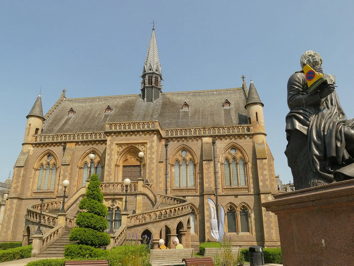
The McManus, ‘Dundee’s Art Gallery and Museum’ is a completely different kettle of marmelade. Housed in its Gothic Revival building, with a statue of Burns outside, clutching the now obligatory traffic cone, you can be forgiven for thinking the 154 year old gallery will be as fusty and Victorian as the V&A is minimalist and 21st century. But this museum is dedicated to Dundee as a whole and encased (literally) in its old-fashioned dark wood cabinets is a fascinating and varied picture of Dundee which brilliantly reflects the complexity of the city itself. Every industry, every era, every entertainment and every local character, is held up for inspection, instruction and enjoyment. You can search Dundee shops in vain for a pot of its ‘ane’ marmelade but you can be sure The McManus has both the story and the requisite artefact. It even gives house room to a small portrait of Dundee’s Victorian ‘bard’, William McGonagall (below right), notorious for his ‘extremely bad’ poetry, and for his (in)famous poem entitled ‘The Tay Bridge Disaster’.


Other indoor adventures consisted of trips to the Verdant Works (a former jute mill), and to the Discovery Centre to explore the Antarctic through the eyes of Captain Scott and his companions. Both are managed with imagination and professionalism by the Dundee Heritage Trust. The RRS Discovery was built in the city and the ship’s design was heavily influenced by the experience of the Dundee whaling industry. We were particularly struck by the enthusiasm and knowledge of the staff. How else would we know that Shackleton’s early departure from Scott’s 1901 expedition may not have been just for health reasons, but also because the pair didn’t always see eye to eye.
Thanks to the Verdant Works, we now know what jute looks like, where it grows and how to spin it into a fibre to make sacks, sails and gardening twine. And we also have a feel for how jute changed both Dundee, the Indian subcontinent, and the whaling industry. The Empire allowed Dundee to flourish - for a while and after a fashion, at any rate. Jute was grown in south Asia and exported to Europe for processing and selling on as a finished project. The factory owners (the ‘Jute Barons’) became very wealthy while the business lasted. In comparison, the Dundee mill workers’ wages were pretty meagre, but the wages of a jute farmer in India were absolutely pathetic. Finally, of course, the balance changed and increasigly jute was retained in Asia to supply the local mills and factories. Jute in Dundee was given a shot in the arm by two world wars - you need a lot of canvas to fight a war - but the heart had gone out of the European business by the latter part of the 20th century and even the Jute Barons had to look to other businesses to maintain their life styles.
Talking of pay, the Dundee mill wage for women and boys under 18 was lower than that for the men. Textile work was often undertaken by women (after all, linen weaving had started out as a home-based industry for women), and it became the norm to lay off the boys as soon as they became 18. During the jute era, therefore, Dundee became a city of working women and it was not unusual for men to become house husbands, raising the bairns at home. Unless you were working in the whaling industry, of course. The discovery that whale oil made processing jute a whole lot easier, meant expansion for the city’s whaling fleet and did no harm to the ship building industry either. The same can’t be said for the whales.


The jute mills were often beautifully constructed. Cox’s stack (above, top left) is the last, spectacular remant of the massive Camperdown Works. The Verdant Works (top right) was constructed with particularly elegant iron work. Dundee has lost much of it's industrial architectural heritage but increasingly these buildings are being converted to other uses, including residential. The main Verdant mill building currently houses mill technology including a steam engine, and an exhibition space. We were lucky to see the last day of a display of embroidered textiles illustrating the Scottish diaspora (above, lower row).
So now to explore Dundee’s cityscape. Many of the buildings are grand and Scottish…


… with beautiful detailed decoration …


… or are quirky and modern.


Walk up Dundee Law for views…


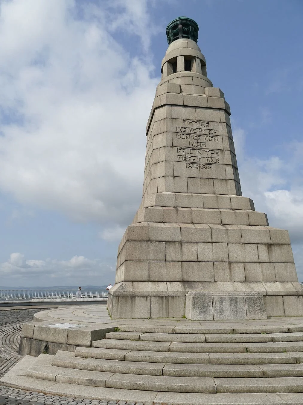
… or turn around to see the war memorial sitting slightly uncomfortably alongside some modern infrastructure, thankfully humanised with some typical Dundee murals.


But what of Dundee’s third ‘J’ - Journalism?
D C Thompson’s was a relatively late comer to the Dundee scene, setting up shop in 1905, but the Thompson family were not new to the city, and started converting their business interests from fishing to publishing in the late 19th century, finally purchasing the Dundee Courier in 1886. In 1905 they merged with the city’s other publishing house, (yes two in one city) and became one of the leading British publishers of the 20th century. Today, they are a significant employer in Dundee, with a stable of publications which includes a number of regional dailies plus many UK wide publications including, of course, the Beano, the Dandy, and the Commando comics. The company’s impact on the city’s design heritage is tangible, and we don’t just mean the courses on offer at the local Universities.


Dundee has a lot going for it. Although many Dundonians must have left for pastures new, surely it is significant that it never made it into the Proclaimers song ‘Letter From America’, itself harking back to the memorable line (‘Lochaber no more’) from an 18th century Jacobite air entitled simply ‘Lochaber’.
The Proclaimers sang:
Lochaber no more, Sutherland no more
Lewis no more, Skye no more …
Bathgate no more, Linwood no more
Methil no more, Irvine no more
So glad that they agreed with us, that Dundee didn’t fit the message.

Because, Dundee is easy to leave. The habour doesn’t feature so much these days, but it has an excellent train service, good road network and even its own airport. Which brings us to two of Dundee’s icons which don’t begin with ‘J’.
These are the Tay Road Bridge (right) and the Tay Rail Bridge, below.
This last image is probably my favourite from the whole trip. You can even see the bases of the original bridge piers (the bridge which failed so catastrophically in 1879) lined up as a memorial, below the girders of the 1887 replacement.

The curse of the wheelie bin
Why has urban design never got to grips with the issue of waste disposal from domestic properties?

© Trefor Thompson
The modern wheelie bin - the current domestic waste container of municipal choice – is cumbersome, ugly, made of plastics, voluminous and ubiquitous. It disfigures the highways and byways of cities, towns and villages throughout the UK. On ‘bin day’, this negative impact is vastly magnified, as we all lug our bins out from wherever we have been trying to hide them, onto the street for collection. At this point, they not only look hideous but block our pavements as well. We gather that even Georgian Bath is now littered with them, despite massive public protest.
So what is the history of the waste disposal container?
Let us step back a few centuries and talk of Pompeii, Paris - and Slough. Most histories of the wheelie bin like to start with a mention of a fossilised, wooden ‘wheelie bin’ found in the ruins of Pompeii (79AD). There are also dark hints of prehistoric bin-like cave paintings in the Himalayas. Terroir is not altogether convinced by these references.
So let’s fast-forward to better documented 19th century Paris and Monsieur Eugène Poubelle, academic, politician and a man ahead of his time (no, this isn’t a joke). Here is an extract of an article published in the ‘French Facts’ section of the ‘The Connexion French News and Views’ (https://www.connexionfrance.com/Mag/French-Facts/Dustbins-are-named-after-French-recycling-innovator):
“The [French] word [for] dustbin – poubelle – comes from the man who invented them in France, Eugène Poubelle.
He was the Préfet of the Seine from 1883 to 1896 and responsible for much of the day-to-day running of Paris.
Collecting and getting rid of refuse was a problem and often people simply left it on the streets.
On November 24 1883, he decreed that owners of buildings had to provide not just one, but three wooden containers, lined with metal and with a lid.
One was for compostable material, one for papers and cloth, and one for crockery, glass and oyster shells.
Not only did he come up with the idea of a dustbin, but also recycling.
However, like most innovative ideas, it was not welcomed by Parisians and there was a huge campaign in the press to discredit Poubelle’s scheme.
Firstly, owners did not want to pay for the containers; secondly, the concierges did not want the extra job of taking them onto the street and thirdly, the rag and bone men saw it as a threat to their job.
Rumours were spread that Mr Poubelle was working in collaboration with the container manufacturers and likely to make money out of their sales.”
Nothing new there, then. The article continues:
“On March 7, 1884 Eugène Poubelle issued a second decree ordering the first ever municipal rubbish collections in the city, which were carried out daily by horse and cart.
He also authorised rag and bone men to continue their trade. He had won with his dustbin idea, but accepted defeat on selective sorting and replaced the obligatory three containers by one bin for everything. That idea had to wait until the 1990s to be re-introduced in France.”
What an unsung hero. If you want to see Poubelle and his poubelles, have a look at https://www.lefigaro.fr/histoire/archives/2017/07/12/26010-20170712ARTFIG00265-quand-le-prefet-poubelle-donnait-son-nom-a-la-boite-a-ordures.php
Laying these historic exceptions aside, it seems as though British rubbish was tolerated in the street, the back yard, the outhouse and the privy until well into the 18th century. The population was relatively small and ‘recycle, re-use and repair’ wasn’t a novel concept, it was just what you did. This situation was excellent for scavenging wildlife such as red kites, which thrived in rubbish strewn London, and for pigs, who recycled much of the food waste, before they became food themselves. Scavenging other people’s rubbish heaps was also popular. One family’s waste may well be another family’s economically viable scrap (rags, bones, metal) or fuel (nuggets of coal lurking in the ash).
All this changed with the Public Health Acts of 1848 and 1875, the requirement for each home to have a moveable rubbish bin, and regular collections.
When team Terroir was in its childhood, inside waste disposal containers were still called ‘waste paper baskets’ and outside containers were ‘dustbins’. Such revealing names. Waste paper was still a minor waste issue, which could be easily contained by decorative containers, some of which were made of woven cane or willow. We can also remember that items such as sweet wrappers or screwed up balls of paper, were often just tossed into the open coal grate. Remember those when they were functional and unfashionable?


Dustbins were kept outside, in the back yard or garden if there was one, and were made out of galvanised metal, with two handles and a lid. They made a wonderful noise if you thwacked them with a football, especially if the lid was loose. This aptly named bin contained an awful lot of ashes and dust as well as anything else which had accumulated in the WPB or the kitchen bin. Keen gardeners also ran a compost heap which took all the vegetable kitchen waste. Rural areas might still have a pig. The dustmen called on a weekly basis and came round the back to collect the bin, hefted it onto their shoulders (protected by those iconic donkey jackets) emptied the bin into the dust cart and returned, sometimes, to sling the bin back where it came from.
The move from metal dustbin and donkey jacket, to plastic wheelie bin, high-vis PPE and hydraulic, bin-lifting lorries is really not hard to fathom. As domestic heating changed from coal to electricity, gas and oil, the need for metal bins to cope with the hot ashes, faded away and lighter, plastic dustbins (remember the labelling of ‘no hot ashes’?) were introduced. There was that tricky period when two bins were needed (a foretaste of the future) but finally coal fires were marginalised and the plastic bin reigned supreme.
With an increase in waste volumes (a move to increased consumption, the throw-away society, more packaging, more plastics, less recycling, built in obsolescence, etc etc), bins on shoulders were less attractive and the donkey jacket became history. Residents were expected to bring their bins to kerbside and experiments with lighter black bin bags failed as they regularly ripped and spilled their contents to the delight of rats, gulls and foxes.

It’s the late 1960s and – drum roll – here comes the wheelie bin. Most ‘bin histories’ credit its invention to a Slough based company called Frank Rotherham Mouldings who created the wheelies to move waste from one end of the factory to the other. A waste talent scout (sometimes identified as a Health and Safety Inspector) spotted the potential as a regular replacement for the dustbin and, with the invention of the automated pick-up waste lorry, our urban landscape changed forever.
If only that were the end of it. As we know, the wheelie bin has proliferated, changed shape, got bigger, got smaller, changed colour, lost its wheels, become stackable, acquired a trolley, lost a trolley, is ridiculously noisy where bottles are concerned, is impossible to clean and can only go out on certain days and on certain weeks. You need a computer to run one efficiently and/or a memory for detail which would win you Master Mind. No wonder they are unloved by house holders and residents.


What are the key issues?
Increase in domestic waste: more waste per person and more people; bigger bins seem to encourage more waste, or maybe smaller bins just make us more careful.

Redefining waste: recycling is largely to blame for the proliferation of bins per household. Terroir currently gives garden space to two wheelies (one for general recycling and one for ‘black bin-bag’ waste) and a food caddy; we give house space to a smaller food caddy and a recycled paper box. That’s five different sorts of plastics based bin, differentiated by shape, colour and wheelie-ness. We also have a compost bucket, but that is self-inflicted.
Some households add on one or two bins for gardening arisings such as prunings and grass cuttings. What is waste? What can be recycled? What goes where? What constitutes ‘rigid plastic’ or ‘clean cardboard’ (those wretched pizza boxes)?

Budgets: some bins go weekly, some only fortnightly to save money. Most of us rely on our neighbours to remember which week it is, and just put out what everybody else has lined up. One of these days, it will all go horribly wrong.
Image © Trefor Thompson

Inequality: not everyone has the space for all these contraptions, inside or out. Not everyone feels up to hauling these so called ‘easy-to-manoeuvre’ wheelie bins up and down the steps which may bedevil access to older houses.
Residents in multi occupancy buildings also have to rely on their neighbours to understand and abide by the rules. Bin lid won’t shut? Bin won’t be collected! Everyone suffers for one person’s infringement.


So why do we put up with it? Why hasn’t ‘someone’ designed an effective waste container which shouts of good design, sustainable materials, and smug satisfaction of recycling well managed? My favourite academic paper on this subject, (Bins and the history of waste relations, Heather Chappells & Elizabeth Shove, (https://www.lancaster.ac.uk/fass/projects/esf/bins.htm), argues that ‘the bin is shaped by and shapes contemporary meanings of waste and management strategies’. Definitely time for a change of bin shape.
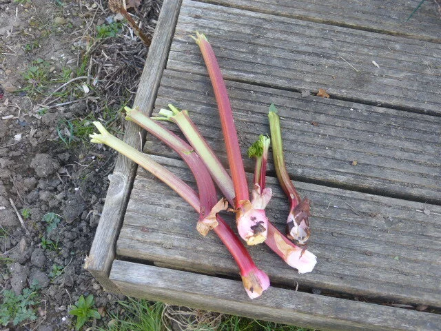
Terroir is still at the Allotment
We’re coping with the rhubarb. The crowns are young but obliging.


Terroir’s cookery section thinks that Rhubarb is so sublime that there is nothing to beat a bowl of the stuff lightly cooked and served with a thick, low fat yoghurt (one of the major suermarkets does an excellent organic yoghurt which fits the bill).
Here’s our approach for really fresh, home grown rhubarb:
Chop into regular sized chunks.
Place in a microwaveable bowl with ground ginger to taste, or use crystallised stem ginger for a bit of luxury. Terroir tends not to add sugar: is this the quality of our rhubarb or a taste for masochism? Whatever, it usually works if you picked the best stems in the first place.
Microwave on high for the minimum time you can get away with and still have all chunks just beginning to soften. By the time it’s been left to stand, every chunk should be soft and juicy with many holding their shape.
Serve warm, or cold from the fridge with the aforementioned yoghurt.
Of course, if you don’t like rhubarb as much as we do, you may prefer this recent recommendation from some of Terroir’s friends: chop rhubarb into very thin slices and then throw in the bin.
Please send us your preferred rhubarb recipes.
Terroir has gone to the allotment
We’ll be back soon.


Please send us your favourite gooseberry recipes.
Here is ours:
Gooseberry and elderflower frozen yoghurt
Tip 400 gm of gooseberries into a saucepan with 200 gm of sugar (we use golden granulated but any sugar will do) and 2 tablespoons of water. Heat gently until the sugar has dissolved and the gooseberries are soft; beat them to a puree.
Add 3 or 4 tablespoons of elderflower cordial, to taste.
Mix 500 gms of low fat Greek yoghurt with 150 ml of milk and mix into the gooseberries.
Pour into a freezer proof container and freeze for a couple of hours. Beat the mixture to a smooth consistency, put the lid on the continer and return to the freezer until fully frozen.
Remove from the freezer for about 10 mintes prior to serving.
The History Hedge
It was a typical Summer ‘21 lockdown afternoon: sunny and warm, a few clouds and an obvious weather ‘window’ for an outing. By the time we got to Nonsuch Park it was overcast. By the time we gave up and left, it was raining. So, here is a very small blog on a very large topic.
Nonsuch Park, located in Surrey but conveniently close to the capital, is just teeming with history: Iron Age remains, Roman occupation (Stane Street now defines the Park’s north western boundary) and an entry in Domesday Book (the village of Codintone, later Cuddington), all predate the creation of the actual Park.
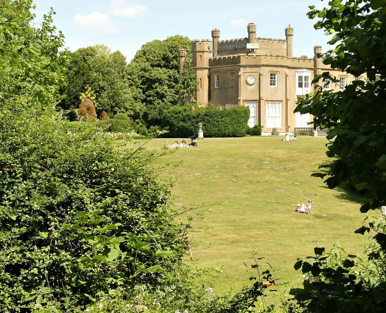
Life changed forever when Henry VIII rocked up, demolished Cuddington (including the manor house, great barn and 12th-century church) and commissioned the building of a Royal Palace with Park to match. The Palace seems to have been a bit of a slow burn. Henry died before it was finished (and the whole thing was pulled down again in the 1680s to be replaced later by a variety of strctures), but the Park had become a fixture and seems to have featured in every subsequent major event in English history. Today, teetering on the border between Surrey and London, the remnants of the Park are on the English Heritage Parks and Gardens Register (Grade II), and include ancient woodland, extensive grasslands and a biodiverse range of flora and fauna. The current early 19th century building (below) is listed grade II*. Epsom & Ewell History Explorer does a useful website (https://eehe.org.uk/?p=25296) or try https://www.woodlandtrust.org.uk/visiting-woods/woods/warren-farm/

And Terroir? We just went to look at a hedge.
We first noticed this hedge when walking the London Loop between Banstead and Ewell, via Nonsuch Park. After leaving Banstead Downs, London loopers skirt Cuddington Golf Course on quiet suburban roads, and take in a short section on the busier A232 Cheam Road, before turning back into residential side roads to cross the London Brighton and South Coast Railway line to access Nonsuch Park.
It was the A232 section which caught our attention. The road is bordered on both sides by substantial hedges which separate and protect quiet, suburban, service roads from the bustling ‘A’ road. These hedges have the ‘feel’ of old country hedgerows – until you stumble over an ornamental cherry or a Norway maple. So what’s going on?
Both on the ground and on the map, the A232 south of the railway line, looks suspiciously modern. It forms an unnatural, sweeping, semicircle and is ornamented by an ambiguous roundabout at the fullness of the arc. It feels like either a low key bypass or an over engineered suburban road, constructed as part of a 20th century residential estate.
As it turns out that we were right, about 400 years out (with the exception of the roundabout, of course). It seems that James I (first Stuart king of England from 1603 to 1625) extended the Park well beyond its Tudor boundaries, such that Stane Street divided the park into two - the Great Park to the north west and the Little Park to the south east. “Originally the road from Ewell to Cheam had run across the Little Park, but this was diverted around its southern boundary, which is why the present Cheam Road (the A232) describes a long curve. This was the only part of the park pale that was laid out from fresh, instead of following an existing property boundary.” (https://eehe.org.uk/?p=25296)

We couldn’t find 17th century map evidence but this extract from an 1896 edition of the Ordnance Survey, clearly supports the 17th century ‘bypass’ theory.

We were right about the 20th century housing estate, though. This 1953 edition Ordnance Survey extract illustrates both the 1930s new build, the roundabout and a section of substantial road widening.
Both maps reproduced with the permission of the National Library of Scotland' https://maps.nls.uk/index.html
So back to the hedges themselves. They are massive and overgrown but the number of different species attests to their age and the species mix is perfectly appropriate to their lowland, clay soil location. The hedge on the south side of the road appears thicker and more substantial, while the one on the north appears to have suffered more disturbance, is thinner and gappier.
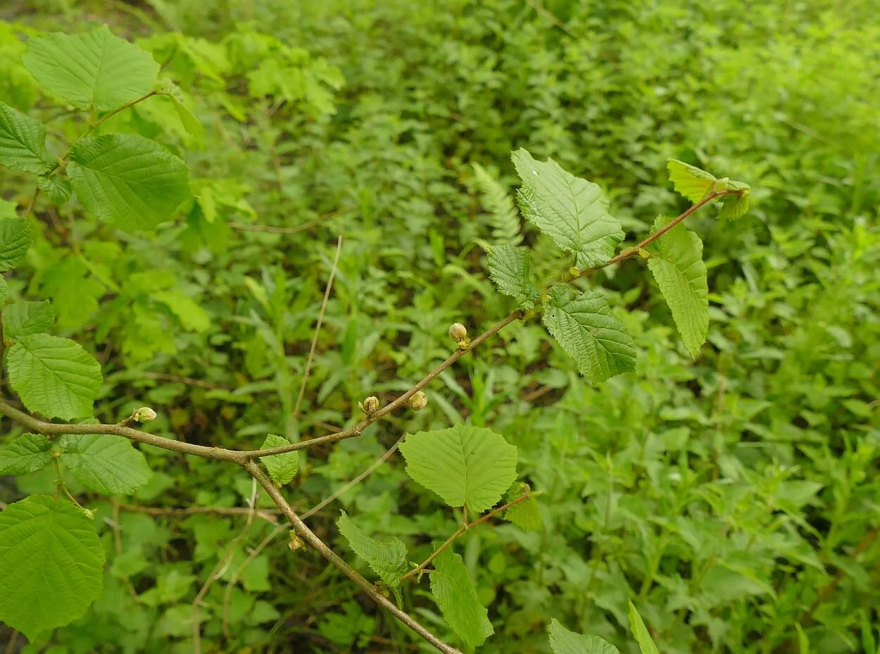
Our attention was caught first by the preponderance of elms, which was a delight. Elms sucker easily along a hedgerow, but if allowed to grow too big, the larger diameter trunks provide a breeding ground for the elm bark beetle, and subsequent death of the elm via the fungus (which the beetles carry) blocking their vascular system which transports water throughout the tree. Coppicing and hedge trimming keeps elms below the critical size and allows the species - and its gene pool - to survive. There was plenty of healthy, vigorous ash, too, although Surrey is heavily impacted by ash dieback and this situation may change fairly rapidly.
Scattered along the length of hedgerow, we also found sycamore, field maple, horse chestnut, yew, evergreen oak, hazel, blackthorn, hawthorn and elder.
Elm - the good and the bad


Field maple, sycamore, ash and hazel


The overall effect


But how are the mighty fallen. The housing construction, and the number of new side roads, must have punched holes in this hedgerow bastion and someone saw fit to plant ‘ornamental trees’ (as if these natives weren’t ornamental enough) to ‘beautify’ the urban area. We found cherry, ornamental crab apples, limes, Norway maples, a walnut, horse chestnuts we couldn’t identify, and an acacia to name but a few, all in various stages of growth, some singly, some in clumps, some even attempting to fill hedgerow gaps, particularly in the thinner northern hedgerow.


To be honest, we found the effect bizarre and unattractive, accentuating and exposing the less attractive elements of the urban area, and totally destroying the beauty and history of the, admittedly overgrown, hedgerows. If the new planting had been well designed, well executed and well maintained, enhancement of this section of the urban area might have been acheived. But these areas seem inconsistent, uncordinated, unmaintained, unplanned and, in terms of creating a decent bit of townscape, incomprehensible and sad. I hesitate to make a joke of it, but it did seem, literally, beyond the pale.
Midsummer
Last week we received an email from a friend who can always be counted on to send beautifully illustrated digital Christmas greetings. This recent email, date-lined June 24th, contained the following message: ‘Christmas Greetings are conventional; Midsummer ones less so but in such a strange year when we have seen few people I thought I would send best wishes and hope that you are well and immunised’.
What a delightful message. No illustration this time, but a mouth-watering description of summer in Provence, with phrases such as, ‘long periods of reliably sunny weather’, ‘eat[ing] asparagus and early strawberries by Easter’ and a warning/promise that ‘summer in Provence is not just about sitting in the shade drinking pastis and playing boules (although those are very important); there are a wide variety of celebrations and events which show a different aspect of local culture from that of winter’. You can read the full version on his website at https://sites.google.com/site/peterdtoon/
Current circumstances ensure that any midsummer greetings from Terroir cannot compete with life in Avignon. We have, however, looked back as far as 2017 and can record that we seem to prefer to spend our mid summers in Great Britain, enjoying the long, often sunny, days on home territory, with children still in school (well, normally) and holiday accommodation relatively easy to find.
Here is our record of our last five midsummers.
Midsummer 2017
We are on Offa’s Dyke working our way between Knighton and Clun. We blogged last year about our long distance ramble along the Marches, but here are some previously unposted pictures of pastoral, patchwork, bosky borderlands. The weather is rather changeable and, one night, it turns really ugly, while we are in the pub. The tent was shredded but thank goodness for a flexible farmer and empty farmyard holiday lets. We return every evening to live in the lap of luxury for the rest of the trek. The views from those dormer windows are stunning.


Midsummer 2018
Now we are in the fens, visiting a friend in Ely. We have set up our tent in an eco campsite (https://www.fenendfarm.co.uk/eco-campsite/), carved out of an orchard and replete with a yurt, a tepee, a travellers’ caravan and ‘pitch your own’ plots, set deep in clearings in a sumptuous wild flower meadow. It was HOT, so part of team Terroir sleeps out under the stars.
Left to right: a tepee in the apple trees; a wonderful display of chicory (Cichorium intybus); the caravan; a flat fenland farm makes your own air strip easy, but possibly less eco


Midsummer 2019

Back on Offa’s Dyke, walking from Clun to Oswestry. The trail crosses the old Oswestry race course. The grandstand, pictured on the information board (left), is now a shadow of its former self (below centre) and the area no longer rings to the buzz and bustle of race meetings, but perhaps the two headed horse sculpture hints of past ‘suspect behaviour’! Two way bet, anyone?


Midsummer 2020
Unsurprisingly, we are based at home. Sign havoc keeps us amused.


Over the midsummer week, we make a couple of socially distanced excursions.
Nonsuch Park on the south east edge of London is the remnant of Henry VIII’s royal palace and deer park. The gardens are great for chilling and weddings (shame about the all-over shaved grass), the wider and shaggier park is wonderful for wildlife.


Collard Hill in Somerset is the midsummer must-go-to place to find the large blue butterfly. Sadly, they appear to be practising social distancing. There are other compensations, however: St Mary the Virgin, Charlton Mackrell, a thatched cottage in Winterbourne Stoke and the greatest midsummer location of them all, dramatically snapped from a moving car on the A303; the photographer was not driving.


Midsummer 2021
We’re still at home! Our midsummer trip is to the Brockham Lime Works, a stunning open space rich in wildlife, industrial heritage and extraordinary walking opportunites. This chalk-based and surprisingly varied landscape is rich in plants, birds, butterflies, bats, reptiles - we could go on. The lime kilns are listed grade II and, in our view, the scenery can compete with the best Europe can offer, albeit on a smaller, man made, scale. We will be blogging about this Surrey Wldlife Trust/Surrey County Council managed reserve in a later post. https://www.surreywildlifetrust.org/nature-reserves/brockham-limeworks
Left to right: meadow brown butterfly on privet flower; quarry cliff now peregrine falcon habitat; former industrial heartland; fragrant orchid (Gymnadenia conopsea)


Belated midsummer greetings to all.
Bute-ified
Serendipity flourishes in a downpour, these days. Our impulse trip to the Dyfi Osprey Project was, literally, a shoo-in as we dodged rain showers, ran into the visitor centre and bought tickets without a thought to advance booking.

A day later, the sun shone and the situation was very different. No matter how earnestly the Cadw staff at Caerphilly Castle studied their daily booking list, whichever way they looked at it, they were fully booked. We were pleased for them and not really disappointed for us, as a do-it-yourself tour around the outside also looked like a very attractive option.
There are plenty of websites detailing the history, construction and development of Caerphilly Castle. It’s an interesting read, but for now we will just record a few key facts selected according to the Terroir view of the world. The castle is of course a significant player in Welsh/English border history, built in the 13th century by Marcher lord Gilbert de Clare (a good Norman name) to protect his domain from Llywelyn ap Gruffudd (a good Welsh name, and self-proclaimed Prince of Wales) who was marching steadily southwards from his North Wales stronghold.
According to various histories, including https://en.wikipedia.org/wiki/Llywelyn_ap_Gruffudd and John Davies’ ‘A History of Wales’ Llywelyn routed Roger Mortimer’s army in 1266, took control of a largish chunk of South Wales, opened negotiations with Henry III and, via the Treaty of Montgomery, became formally recognised as Prince of Wales, for a cost of 25,000 marks (5,000 marks extra if he wanted the homage of Maredudd ap Rhys of Deheubarth) in 1267.
Understandably, de Clare was somewhat rattled by developments and started building Caerphilly Castle in 1268. Davies comments, ‘one of the most remarkable buildings of the Middle Ages was constructed in order to frustrate [Llywelyn’s ambition]. That building was Caerphilly Castle, a symbol of the pride of the house of Clare and an abiding reminder of the strength of Llywelyn’s appeal to the Welsh of northern Glamorgan.’ Negotiations and armed attack on the castle failed, however, both with de Clare at Caerphilly and elsewhere in south Wales. Llywelyn had peaked and his tide of success was on the ebb. He defaulted on his annual tribute payments, his family turned on him, and, after a messy decade of fighting and feuding, Llywelyn finally met his end in December 1277. Caerphilly Castle was promptly transformed into a massive mansion with hunting lodge.
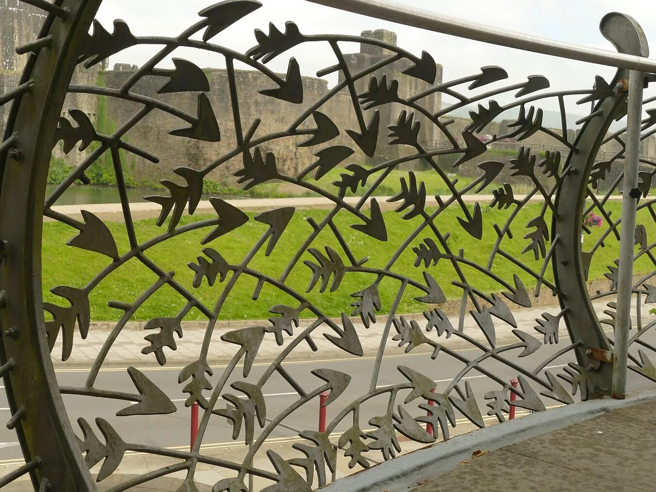
In 2021, it is still outstanding (literally) for both its size and its waterscapes, and skirting all of this pleasurably extends our walk. In terms of size, it is one of the largest castles in Britain, second only to Windsor Castle. Sorry Wales! There is a cunning little Cadw CGI video (https://www.youtube.com/watch?v=sNIvZl_K45M) which gives a curious raven’s eye view of the castle’s construction. The number of gates, portcullises and draw bridges is positively dizzying, presumably a reaction which was shared by the 13th century Welsh.


Caerphilly Castle doesn’t just have a moat, it has massive ‘water defences’, which seem to have been extended in peace time with the addition of a northern lake. Mown grass and large bodies of water are goose heaven, of course, and a huge flock of Canada geese mingles with a smaller gathering of greylags. There is a great gaggle of adolescent goslings piled up on a grassy slope like a teenage duvet which has come loose from its covering.


Follow the goose footprints around the castle and over a bridge (why swim when you can walk?) and you come to Canada goose suburbia, on the edge of the northern lake. Not a greylag in site but some of those fanciful Indian runner duck/mallard crosses are sprinting up a nearby slope. Should we be calling them delta runner ducks, these days…?


You can see why geese become so unpopular in many parks. Lush and varied grass/wildflower areas can go from this (below left) to this (below centre), when a hungry colony of Canada geese move in. With few predators, control can be tricky and unpopular with the human community. An integrated management system is often used including licensed control of adult numbers and eggs, fencing of banks and grazing areas (below right), and bank barrier planting. We assume this is what is happening here.


Turning a corner, a public walk opened up before us, sandwiched between walls of disproportionate heights - one to keep us out (on our left) and one to keep us in, or rather on, dry land (to our right). The view of the Castle was spectacular and duly appreciated, but the real eye catcher was the wall-and-mortar habitat which accompanied us all the way down our stony promenade.


This apparently inhospitable environment is home to an array of tenacious plants which can thrive in man-made structures like stone and brick walls. Drought resistence, a love of lime (mortar is lime based, of course) and a natural habitat in rocky areas are, understandably, an advantage, writes Terroir’s botanist. At this time of year, ivy-leaved toadflax (Cymbalaria muralis) is a real scene stealer (left) but the clumps of Pellitory of the Wall (Parietaria judaica), with their spikes of tiny flowers (right), are also putting on a brave show. For audacity, however, it’s hard to beat maidenhair spleenwort (Asplenium trichomanes) (centre). It was years before one member of Team Terroir realised this was a real fern, after receiving a sprig of it attached to a childhood Easter egg. Looking back, we hope it was a clever imitation but, regretably, we doubt it.


My favourite, navelwort (Umbilicus rupestris) aka pennywort, penny-pies or wall pennywort for obvious reasons, grows prolifically on the tall, shady, castle wall to our left.
Many of the other plants we encounter are less obviously linked with rocky or wall habitats, but are well known for their invasive qualities, able to gain a foothold at the base of the wall, where something akin to soil is starting to accumulate, and away from the destructive pressure of passing feet.


From left to right: a generous growth of ragwort (potentially poisonous to live stock which is not an issue in this location)
herb robert (Geranium robertianum), hunkered down with a dock and some pellitory of the wall
spear leaved willow herb (Epilobium lanceolatum)
and a sow thistle (Sonchus sp)


Grasses include, from left to right:
Yorkshire fog grass (Holcus lanatus), Smooth Meadow Grass (Filipendula ulmaria) and a rather blurry picture of sweet vernal grass (anthoxanthum odoratum), an important contributor to the equally sweet scent of hay
Llywelyn didn’t manage to do much damage to Caerphilly Castle but anno domini did. Enter the Marquesses of Bute: Marquess 1 bought the ruins in 1776, complete with leaning tower and, no doubt, plenty of dodgy masonry. Marquesses 3 and 4 were passionate about architecture and heritage and had also acquired an immense fortune from the south Wales coalfield. No. 3 set about clearing the urban sprawl which was encroaching on the site (Terroir has yet to find out what the inhabitants thought of this) but No. 4 may have become Caerphhilly’s hero with a massive restoration project from 1928 (Great Depression time) to the start of WWII, employing significant numbers of locals in both skilled and labouring activities. The perceived wisdom at the time was ‘keep as found’, but that was a mantra which the Butes had no intention of following! Finally, Marquess No. 5 gave the Castle to the State and further conservation work was carried out by the public purse in the 1950s and 60s. Now, Cadw has stepped into the shoes of some pretty impressive former owners. Thanks to Wikipedia and Cadw for help with this section. (https://en.wikipedia.org/wiki/Caerphilly_Castle and https://cadw.gov.wales/more-about-caerphilly-castle)
Finally, we are pleased to report that Cadw and Caerphilly have a sense of style, and a sense of humour. Here are:
Artist Rubin Eynon’s story telling gates (we were allowed to sneak in to get a better view of these functional, flowing, metal and glass structures)
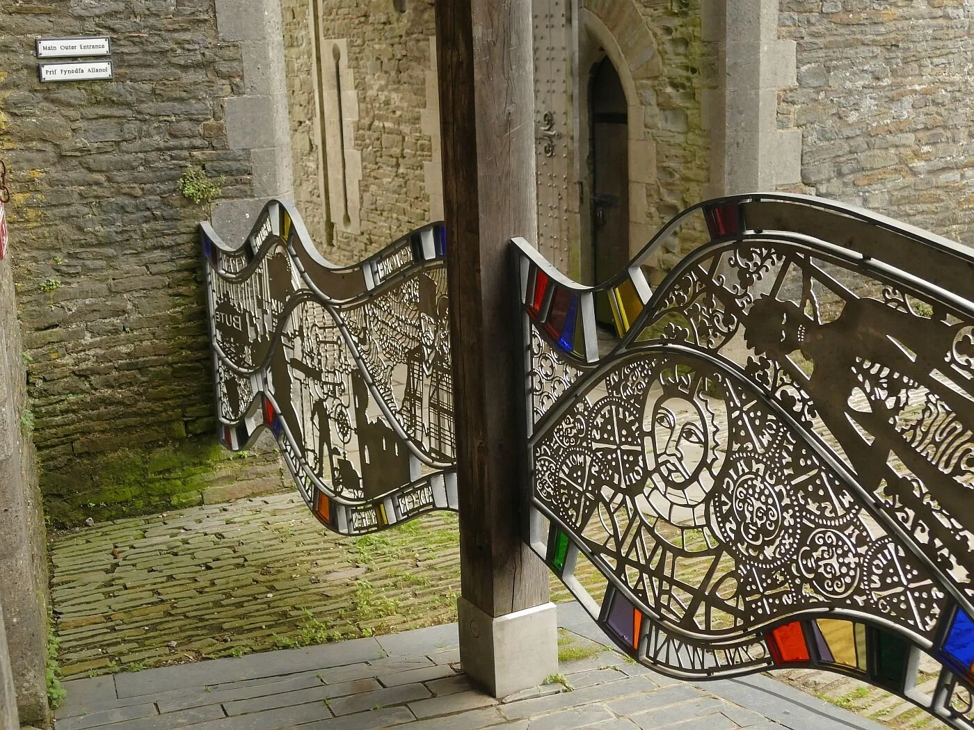


Sculptor John Merrill’s figure of the fourth Marquess of Bute, propping up the leaning tower
and medieval fire power - as street furniture and as a rather dark health warning - and an easily recognisable local hero.


Tan y tro nesaf/Until next time.
A Flying Visit
Live streaming wildlife webcams have never dominated Terroir’s leisure time. We’ve always enjoyed, indeed marvelled at, BBC’s Spring and Autumn Watch and many other programmes and websites which use them, but we’ve never been hooked. All that changed last week.
On a characteristically damp and misty journey through Wales, we passed the Dyfi Osprey Project located off the A487 near Machynlleth. ‘Not the day for a visit’ we cried, ‘terrible visibility’ we exclaimed, as we slammed on the brakes, turned the car and headed for the car park.


Thankfully the project’s new visitor centre is welcoming, light, airy and, on a wet June day, warm and dry. The seating features recycled church pews and the staircase is enclosed by curved, polished timbers, reminiscent of a whale’s rib cage.


But the big question is, are we going to see any ospreys? On one side of the visitor centre, partially hidden but still very eye catching, are four enormous screens showing the intimate details of ‘Idris’ and ‘Telyn’’s family life, perched high on a nesting platform, somewhere out in the mist. We’re hooked immediately. The quality is excellent, the action live, the volunteer on duty informative, cheerful and enthusiastic. To hell with the weather! The view is much better inside.
The male, Idris, has already swung past with a fish, and the two chicks have been fed and have hunkered down. We are told that ‘Telyn is doing her umbrella imitation’, and has spread herself over her sleepy offspring to protect them from the rain. It doesn’t matter that we’ve missed the male, that the chicks are invisible, that the nesting platform is artificial and that we are far away in the warm and dry. It is nature in the raw and is utterly compelling.

Osprey’s have long been a conservation icon. I can remember as a child, having an RSPB jigsaw puzzle featuring an osprey (Pandion haliaetus) speeding across a watery surface, a fish firmly clamped in its claws. Today, Wikipedia and most wildlife conservation organisations have website pages devoted to these raptors, although amounts of detail vary.
As with many raptors, their extinction from the UK was probably complex. The Victorian hunting/fishing/collecting fixation must have taken a huge toll, including egg collecting, shooting for taxidermy (not just antlered stag heads on castle walls) and probably to prevent osprey predation on sport fishing.
The Wikipedia article (https://en.wikipedia.org/wiki/Ospreys_in_Britain) suggests extinction as a breeding bird in England by 1840, and absence from Scotland from 1916 to 1954, when a Scandinavian breeding pair rocked up at Loch Garten, in the Cairngorms, north east of Aviemore. The RSPB’s Operation Osprey opened to public viewing in 1959, and ten years later the Scottish Wildlife Trust reserve at Loch of Lowes (further south, near Dunkeld) was also supporting breeding pairs.
Other conservation projects have followed. The ground breaking project at Rutland Water (Leicester and Rutland Wildlife Trust) produced Terroir’s first off-jigsaw viewing of an English osprey. Pairs have been successfully breeding here since 2001. Other Wildlife Trusts’ osprey havens include Kielder Forest in Northumberland, (first breeding pair in 2009), the Dyfi project in Montgomeryshire (a breeding pair since 2011), the Lake District (Foulshaw Moss – first breeding pair in 2014) and Llyn Brenig (North Wales Wildlife Trust, first breeding pair 2018).
Life is still tough for opsreys however and it’s not just about rain and wind. The Llyn Brenig centre suffered a horrific act of vandalism in May this year when their nest platform was felled with a chainsaw. Other threats include contamination of birds with mercury and organochlorine pesticides, entanglement in fishing line and being shot while migrating across southern Europe – the birds winter in Senegal.

Which brings us neatly back to Dyfi and the need to debunk the romantic myth that these birds mate for ‘life’. The birds live independently through their Senegalese winters; if one doesn’t make it back to Northern Europe, then the pair bond is broken and another mate has to be found; this may happen quite frequently in any one bird’s lifetime.
When Nora failed to return in 2013 (see time line above, right), the Dyfi website (https://www.dyfiospreyproject.com/) tells extraordinary stories of violent, aerial, all female, ‘cat’ fights taking place over the lonely Monty. The winning ‘gal’, christened Glesni, had to fight again, the following year, to retain her pair bond. Would Monty have accepted a new mate, if Glesni had lost the battle? It all sounds so Thorn Birds, so Foresyte Saga.
As it had stopped raining we ventured out to tackle the board walk from the osprey visitor centre through the Cors Dyfi nature reserve, to the viewing tower. No ospreys visible of course, but plenty of surprises. The centre is located in the lush, damp, Dyfi valley, formerly a peat bog, then planted with conifers and now being returned to bog again. There is plenty of open water to provide provender for a nest of hungry osprey chicks, but wet scrubland, rushes, and water loving wildflowers also abound.
Wet scrub


Wild flowers, left to right: ragged robin, yellow flag, water dropwort and cotton grass


As we climbed the viewing tower steps we were caught by a tangible buzz of excitement and joined the - socially distanced – row of assorted bird enthusiasts watching a couple of young long-eared owls perched in the willows below. ‘That’s a real ‘tick’ for round here’, one said. The Reserve’s dense scrub seems to suit them well.
The other, big, surprise for us were the beavers. The reserve has started a - licensed and heavily fenced - beaver colony to help manage all that willow scrub which is holding back re-conversion to peat bog. Two beavers – father and son - arrived in March and recently the mother was added to complete their domestic bliss. We gathered that, as the colony grows, it is hoped to create further enclosures to spread the impact of these ‘ecosystem engineers’.
Beavers have been extinct in Britain for around 400 years, thanks to the fashion for beaver fur hats, for beaver meat, for a secretion they produce called castoreum and probably because they were also regarded as pests. The recent re-introductions of beavers have not been universally popular. As far as Terroir is aware, there are no intentional, free-roaming beaver trials in England and Wales (please correct us if we are wrong) although the River Otter beavers in Devon have, we understand, been given leave to stay after the results of a five year montoring period (again, updates appreciated).
We didn’t see the Dyfi beavers (obviously - see below, right), but we did discuss project security with one of the duty volunteers. It is important that they don’t escape and the Dyfi beaver fence is, we gathered, inspected very regularly. We were particularly intrigued by a complicated device which seems to involve apples and carrots and a web cam (Dyfi Project, please forgive us if we haven’t got this quite right!); apparently the beavers can be relied on to visit this free food source daily, thus providing an easy head count on a very regular basis!


The beavers deserve a blog in their own right. And, in comparison, it sounds as though ospreys have had it relatively easy.
Now, back to that webcam….

© Montgomeryshire Wildlife Trust, reproduced with permission Image captured 16/6/21
The Brylcreem Girls
‘Last chance to see herd of elephants in Chelsea’ read the headline on the Southwest Londoner webpage (https://www.swlondoner.co.uk/news/04062021-last-chance-to-see-herd-of-elephants-in-chelsea/). We had been watching the progress of this particular migration with curiosity and, as we had missed the elephants' crossing of the Mall, we decided to try our luck in London’s latest wildlife park on the Cadogan Estate, in Duke of York Square.

The great Mall migration © CoExistence
You have probably guessed by now that this Band of Mothers (elephants are strongly matriarchal) is not a trumpeting, earth-stomping, tree-rubbing, flesh and blood herd. But neither are they purely an artistic venture; they are part of an educational and ecological endeavour to raise awareness of wildlife conservation and problems of co-habitation between elephants and humans, all courtesy of ‘Coexistence’ (https://coexistence.org/about-coexistence/):
‘As the herd make their way around the globe, they will tell the story of our over-populated planet, the effect of human encroachment on wild spaces and the inspiring ways we can coexist with all the other living beings that make our world magical – from tigers and orangutans to nightingales and elephants.’
These elephants are made from a plant called Lantana camara, a native of Central and South America. It’s a member of the Verbena family, has numerous local names, including yellow sage, and is offered to British gardeners by a number of well-known commercial nurseries. It is highly toxic and has spread, not just to UK patios and conservatories, but throughout the world, where it
‘can outcompete native species, leading to a reduction in biodiversity. It can also cause problems if it invades agricultural areas as a result of its toxicity to livestock, as well as its ability to form dense thickets which, if left unchecked, can greatly reduce the productivity of farmland’. https://en.wikipedia.org/wiki/Lantana_camara So this not just about elephants, it is about habitat and humans, as well.
Below: the deceptively pretty flowers of Lantana camara


We had puzzled over the construction of these full size sculptures. In their press photos they look sleek, polished, and reminiscent of the wooden carvings which used to adorn so many side tables and mantelpieces. Close to, you immediately understand how verbena can create a tusker: basically they are just a herd of enormous wicker chairs. And, from the middle distance, the strands of plant material, stretched over a metal skeleton create an impression of carefully slicked back hair, held in place by vast quantities of gel – like elephantine Brylcreem Boys.


This is not to demean the elephants’ impact, however, and the sight of a full herd marching across Duke of York Square, or small groups loitering in corners of pedestrianised Chelsea shopping precincts, is certainly arresting and memorable.


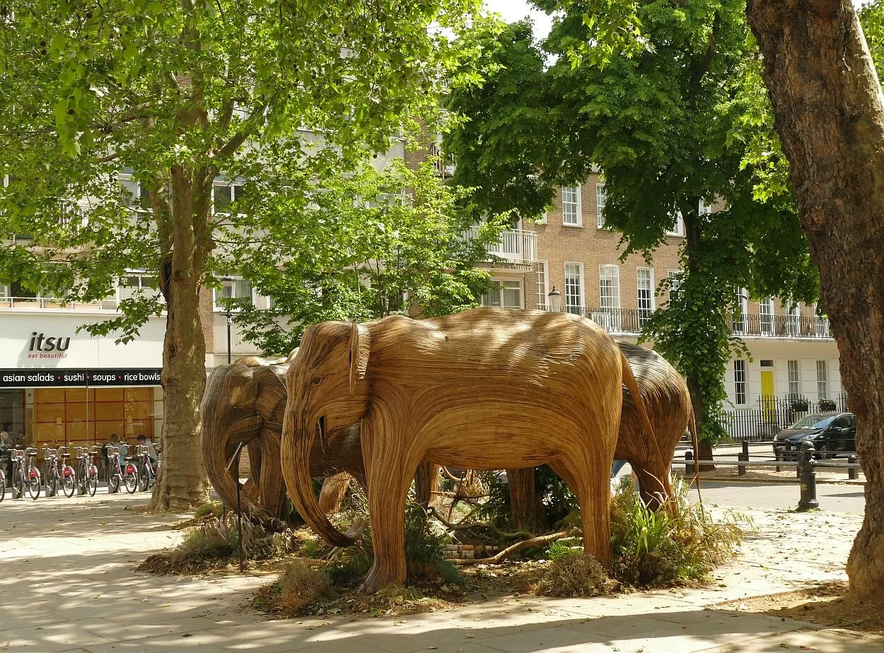
On the other hand, their basket case construction and their location adjacent to high end market stalls and restaurants, renders them friendly, endearing and almost cute. Their press team may not have helped either: ‘experience them in all their glory and bask in the ambiance of Xerjoff perfumes made with ingredients taken from the jungles of India’. The air of Chelsea was warm and pleasant but, thankfully, we could detect not a sniff of either elephant dung or jungle perfume.

In their natural habitat, however, elephants are seldom described as ‘cute’. They are large, loud, and scary, and it is not surprising that the problem of integrating human and elephant needs is one of the big issues which Coexistence seeks to address. But ‘these majectic cratures’ are much more fragile that they look.
So, is this the best way to highlight the plight of these wild beasts?
London has already hosted a herd of Bronze elephant orphans, and there are other elephant focussed campaigns such as the Elephant Collective (https://www.therealelephant.com/) or the Elephant Family (http://elephant-family.org/). This blog has, however, already touched on the difficulties associated with single specie conservation, and the need for holistic habitat management to sustainably improve biodiversity (Blog 19, Walking the Line, 4th March 2021, butterflies as conservation emblems). Using large, furry or cute wildlife as figure heads for wider conversation initiatives may be very effective in the short term. Let’s hope it can also deliver on a long term and habitat wide basis.
In the meantime, however, if you fancy a gentle afternoon out with a herd of benign and creative elephants, then these Indian pachyderms are for you - enjoyable, soothing and a lot easier to get on with than the originals. If you decide to buy one, of course, it could be very painful on the wallet, but let’s hope, it will be in a thoroughly good cause.
And, by the way, the Chelsea pensioners seem to get younger everyday.
I Spy
Pre Covid, Terroir defined four criteria for determining where we wanted to live. These criteria were, in no particular order:
· Good transport links to make leaving (and coming back) easy! Tick
· Access to a lively city with plenty going on. Tick (in fact 2 cities within easy reach)
· Great countryside. Tick (lovely, long linear belts of the stuff)
· Near the sea – it takes about an hour to reach the coast from the current chez Terroir, so seaside is technically null points but not an impossibility.
Three out of four suits us pretty well for the time being.
With regard to our local countryside, familiarity has not bred contempt. A couple of days ago, we trialled anther local Slow Way (see Blog 29, on 13th May) and were embarrassed but also delighted to find that here was another walk which we had never tried before. We climbed the scarp face of the North Downs, turned round and admired the view.
Here are a couple of samples, the distant haze showing just how hot a day it was turning out to be.


As we contemplated the panorama, we started that conversation which is usually spawned by looking down on a familiar landscape from an unfamiliar view point. It went something like this: ‘Oh look, there is St John’s Church tower. Can you see that tower block? Where is the new school? Why can’t we see the railway?’
Here is a list of all the things we spotted. Can you find them?
13th century church tower, Victorian church tower
A Capability Brown landscape
Two motorways and a lot of railway,
Telecomms tower
Sand quarry and a landfill site
A high pressure gas pipeline (trick question)
1930s housing
1960s block of flats
21st century housing estate on former minerals site
20th century industrial estate, 20th century commercial ‘sheds’
21st century primary school
Answers below!
It is amazing what you can hide in a summer landscape. We will go back in the winter to see just how much a visual impact assessment is influenced by seasonality.
So here are the ‘answers’. This second set of photographs has zoomed in on sections of the view, panning from east to west. Terroir is standing on the crest of the North Downs chalk ridge, looking south across the gault clay below, to the Greensand ridge on the other side of the valley.

This is, pretty obiously, one of the two mortorways, in this case the M23 heading towards Gatwick Airport. For once we were unable to see the airport buildings from our viewoint and, as the aiport is pretty much closed, there was no flight traffic to indicate its whereabouts.

Next up is the sand quarry, tucked in at the foot of the greensand ridge. A hint of the 1930s housing can be seen at the western extent of the picture.

Picking up again on the tile roofs of the 1930s housing estate, we have moved west to the landfill site. At gound level, this seems like a veritable mountain, especially as it is so obvious now, in its white shroud, waiting for final restoration. From our viewpoint above it looks more like a water body. The fields rising behind the white mound are older reclamation works, from the area’s long history of Fullers’ earth excavation.

Now we move on the to the industrial estate - the collection of light coloured roofs to the right of the image - which is a suprisingly extensive affair of light engineering, car show rooms, vehicle repairs, interior and exterior building trades etc - bounded by one of the railway lines (so hard to see). The 21st century housing estate, just off picture, comes snugly up to its boundary.

Moving ever westward into increasing haze, we can just pick out the spire of the Victorian church on its wooded knoll, just under the skyline to the left of the picture. Here is also the paraphnelia of the local town looking, from this height, as though it lies in a woodland clearing. The block of flats (right of photo) looses its dominance when seen against the wooded hillside, but the 20th century commercial ‘sheds’ are very visible below. These latter lie adjacent to the main railway line, which is entirely hidden by the early summer foliage.

Moving form the 20th century sheds, you can just make out the blocky shape of the 21st century primary school just to the left of centre of the photo. The wedge of green sace to the right is an outlier of the Capability Brown landscape!

The North Downs are back in the picture now. Another railway line runs parallel to the chalk escarpement, but is impossible to see. Once renowned for its views of the Downs, the trackside scrub and tree growth is rapidly expanding, reducing vistas of the Downs to just quick glimpses - and hiding the railway itself from the views above.

And there is the telecomms tower, exploiting the North Downs ridge to provide signals to north and south. Less obvious, but there if you look carefully, is the spire of the 13th century church; a dark grey cone piercing the tree canopy, just right of centre on the photgraph.

Finally, we have swung full semi-circle to watch (and sadly listen to) the M25 carving its way up the North Downs escarpment to its highest point at 213 m above sea level.

And the gas pipeline? Well it goes under the view somewhere. When we had finished admiring the vista, we turned round to continue our walk and spotted the tell tale red topped marker over to our left.
The Darling Buds
This time last year, the ‘darling buds of May’ were unshaken by rough winds and were sunning themselves in our much appreciated parks and gardens. Terroir’s plot was full of weeds, of course, but also colour, butterflies and bees.
Mid May 2020


This year the garden is a wonderful fresh green, a delight to behold but distinctly monochrome and very damp. The aquilegias are providing spikes of red, blue and purple, the bluebells are hanging on, but the apple trees are so behind that one is still in flower and none have set fruit yet. Otherwise, it is a mosaic of verdant foliage. I have never seen such a gigantic crop of cleavers (Galium aparine). The bees are making the best of a bad job but the butterflies are few and far between. Too cold, too wet, too windy and garden development is seriously delayed. The photographs (above and below) make an interesting comparison - same plants but different years.
Late May 2021


This weather has also been a big factor in our (lack of) outdoor exercise, but now the rain has ceased and the wind dropped, it is time for another visit to the Moors (see 29/10/20 , 7/1/21 and 11/2/21 for the back catalogue of Moorish blogs). How has the weather impacted on our local wetland nature reserve?
The walk reminds us a little of those horticultural shows where size matters. Here we have the biggest shoals of cow parsley (seen below peeking over a railway bridge, almost as tall as Terroir), the tallest stands of dock spears and the widest ‘spades’ of burdock leaves that I can remember. The cleavers are pretty upstanding too but I still think that chez Terroir will win the cup for longest and fattest sticky willy (aka goosegrass, catchweed, stickyweed, sticky bob, stickybud and many, many more highly descriptive names).


On a smaller scale of leaf but larger scale of structure, the freshness of the tree foliage still allows the sculptural quality of the trees’ wooden skeletons to be admired. It will be a while yet before the ‘spring greens’ pass to the heavy, stately, dark greens of high summer.
Underneath the branches, the bluebells are overblown and fading but still manage a hint of that blue miasma which brings magic to every spring bluebell wood. Bedraggled forget-me-nots and self heal add to the blues, but there are just a few stands of red - or perhaps startled pink would be a better description - campion that suddenly pounce on you from behind a clump of grasses. The willow herb has a way to go yet in terms of height, let alone flower and last years dead stems (bottom row, left) indicate just what it has yet to do to match last summer’s blaze of colour. The garlic mustard and buttercups are irrepressible, of course, but the biggest surprise is a clump of daisies, raising their faces to the light and smiling like cheeky children at the shock they are creating by their presence.


The blackthorn has finished flowering of course but the guelder rose is holding up its lace cap flower heads like doilies on a tea tray (below, left). The hawthorn has also managed to bloom within its eponymous month of May. Did the ‘darling buds of May’ refer to the month or the hawthorn flower, and did Shakespeare consider May time to be summer? The answers to these questions are probably irrelevant as I’m pretty sure that a good rhyme was more important to Shakespeare than consideration of phenology or calendar. You try finding a decent rhyme for ‘June’.


There are still some willow catkins but the alder and hazel have moved on and are quietly presenting the next generation of cones and nuts for whatever super-spreader (wind or animal) will be required to complete their lifecycles. There is excitement at the site of a young oak sporting what appear to be red berries, but which we assume are a type of gall. Does anyone know which sort they are?


The horse chestnut candles are bedraggled but finally blooming bravely. It’s at this time of year that the non-natives become obvious, in this case with a red blossomed horse chestnut tree. The American oaks, which also adorn the Moors, become distinctive in the autumn with their dramatic red fall colours.
As with the rest of Surrey, the ash is late and very hesitant. Whoever penned ‘ash before oak – we’re in for a soak; oak before ash - we’re in for a splash’ needs to define their time frames. We had a pretty thorough soaking this spring before the ash appeared, but if it refers to summer weather, then there is still time for the old saying to ring true. Ambiguity is so good for successful weather forecasting.


But, as usual, it is water which steals the show on the Moors. For those who are new to the blog, the Moors is a local, Surrey Wildlife Trust, nature reserve sandwiched between a railway line and a landfill site, and exploiting an exsiting brook and former sand and fullers earth excavations. It’s hard to read the former landscape in the riot of habitats which now abound here.

Inevitably the water level in the seasonal lakes and ponds is high, but the floods have retreated and the footpaths and cycleways are passable if muddy.
It’s easy to see the regular users here - walkers, dogs and cyclists - although the burdock is doing its best to obscure the prints and narrow the path.
The wetland vegetation is growing fast, although only the yellow flags have started to flower. On the lake edges there is space for the water mint to take hold and flourish before the reeds shade it from view.


The swans on the upper lake are watchful but there are no cygnets and their nest is now hidden in the reeds. A great crested grebe and a mallard (both males) are both showing off but there is no sign of their respective mates. We just can’t get a picture of the grebe with its ruff extended in full Elizabethan splendour, but the mallard is happy to give us a ‘daffy duck’ shot. The tufted ducks are absent but a couple of coots are on the water. All in all, though, it’s quiet on the duck front today. On the other hand, two juvenile cormorants are drying their wings, perched on the old fence posts which cross the upper lake, while a heron stalks the shadows.


Further upstream, a sodden meadow currently bears more than a passing resemblance to an 18th century English landscape park, in miniature. Not bad for an old mineral extraction landscape and a wet and windy spring!
.
Isabella Slade
There are times when only a walk in the Park will do.
And there are times when only a Royal Park will cut the mustard.
An ebbing lockdown is just one of those times and Richmond Park is just one of those open spaces. We started early, took our dog – no, no, wrong poem. We started early to find a parking space; already that adventurous idyll is fading, but at least our companion of choice arrived by bicycle.
Dodging speeding cyclists as we crossed Queens Road, we stepped out across the deer strewn grassland, under trees high-pruned to the exact stretch of a red deer’s neck, and skirted massive chunks of felled or fallen timber, which provide sculptural, dead wood habitats for what we hoped was a spectacularly diverse array of invertebrates. The cynic in me wondered if anybody had ever complained about the dead wood ‘scatter’, on the basis of it making the Park look untidy.


After an hour in a car, it was revitalising to re-orientate ourselves in parkland which extends over 2,500 acres (I checked this on the website and, yes, they do measure this enormous, 800 year old Royal Park in old money), located within 12 miles of St Paul’s Cathedral. Or, if you prefer, over 1,000 hectares of parkland within 20 km of the City of London. https://www.royalparks.org.uk/parks/richmond-park/
It’s the place to be in a pandemic. Charles I removed his court to Richmond Palace in 1625, to escape the plague, and enjoyed it so much that he enclosed the Park in 1637. As ever with enclosures, this move proved unpopular with the locals but pedestrians were allowed a right of access. It was this right, as well as our legs, which we were exercising during the current pandemic.
It’s still a heavily protected landscape although these days by legislation rather than the walls. It’s a National Nature Reserve, London’s largest Site of Special Scientific Interest and a Special Area of Conservation. This last is a European designation, which has been transferred across the Brexit enclosures to operate in England and Wales. But hey, this is supposed to be a rejuvenating walk in the park, not a history and politics lesson.
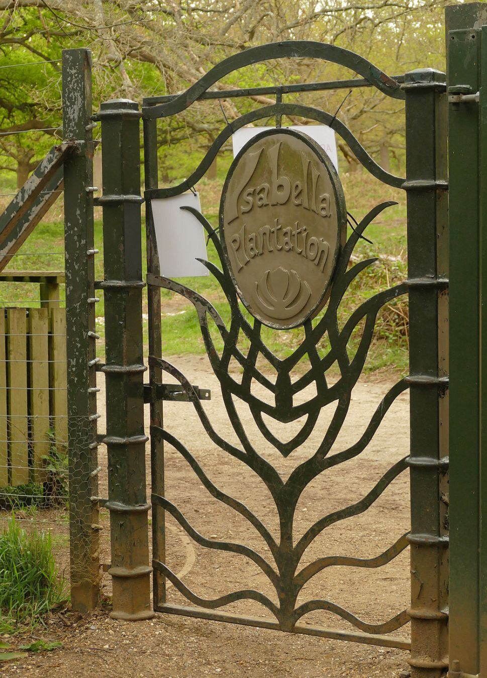
Today’s destination is the Isabella Plantation, a more recent ‘enclosure’ which, at this time of year, promises colourful therapy to senses jaded by lockdown and ‘stay local’ limitations. I suppose the additional plastic signs, on the back of the gate, are an inevitable part of Covid ‘road map’ life.
As a part of a Royal Park, I was imagining the eponymous Isabella to have royal connections, if only in the sense of a Nell Gwyn or a Lily Langtry. In fact, Isabella Slade comes from humble and geographical origins. At best, suggests the website, Isabella might have been a staff member’s wife or daughter, but the author obviously favours the corruption theory: ‘it is more likely to be a corruption of the word isabel, which was used as far back as the 15th century to mean dingy or greyish yellow - the colour of the soil in this part of the park‘. This is a definition new to Terroir but corroborated by Wikipedia (https://en.wikipedia.org/wiki/Isabelline_(colour)). And Slade? Apparently this part of the Park was known as ‘The Sleyt’ in the 17th century, a name used for ‘boggy ground or an open space between woods or banks. By 1771, it is shown on maps as Isabella Slade.’

By 1831, 17 ha (42 acres) had been fenced off, planted for timber with oak, beech and sweet chestnut, and renamed Isabella Plantation. A second makeover started in the 1950s, to create a damp, woodland garden. Large quantities of Rhododendron ponticum (that weedy thug of many British landscapes) were removed, and replaced with azaleas, more interesting and less invasive rhododendrons and a good range of other exotic trees and shrubs.
There are lots of interesting things to say about Isabella. She/it contains the National Collection of Kurume Azaleas, brought back from Japan by plant hunter Ernest Henry ‘Chinese’ Wilson in the 1920s. We also have to note that E H Wilson was born in Chipping Camden, on the other side of the hill to Ilmington, the subject of Blog 22, on March 25th.

Biodiversity is taken pretty seriously, it seems, and plantings of native flowering and berry bearing trees and shrubs grow alongside the exotic vegetation, to enhance the habitat for birds, bats and insects.

A Heritage Lottery Fund/SITA funded access project seems to have done wonders for paths, vegetation management and the wetland environment. All these aspects were delivered to a very high standard on the day of our visit. Even the rain held off.
Apparently there are some very eco-friendly toilets, but Terroir is not in a position to comment on these.
The plantation is regularly infested with Oak Processionary Moth (OPM), the hairs of which, IF TOUCHED, can trigger skin rashes and respiratory problems. Control is carried out by spraying with insecticide (the Plantation may be closed during spraying operations). We could spend quite a lot of time discussing the pros and cons of OPM control.
But
This blog is meant to be about spiritual refreshment, colour therapy, relaxation, an antidote to lockdown, tranquillity, a shared experience with nature and a friend.
Let’s go for walk.
The colour therapy:


The wetland - those skunk cabbages are just lapping it up:


And the Japanese Kurume Azaleas:

Feeling better?
Slow Ways
Maybe Terroir should adopt this as a slogan, as we have been rather slow-moving in picking up on the Slow Ways project. In case that goes for you, too, I’ll tell you what we know about it so far.
If you go to the project website https://beta.slowways.org/ you may be somewhat phased by the Home Page which hits you between the eyes with a nodal and very purple matrix which looks more like a protein network than an invitation to amble across Britain! Each node is a city, town or village and the aim is to connect them by creating a unique network of walking routes. Wheels are allowed, but only if they belong to a wheel chair or children’s buggy.

‘Using existing paths, ways, trails and roads, people can use Slow Ways routes to walk or wheel between neighbouring settlements, and combine them to create longer distance trips. It’s designed to make it easier for people to imagine, plan and go on walking journeys.’
As far as we can see, it is the brain child of Dan Raven-Ellison, self-styled ‘Guerrilla Geographer and Creative Explorer’. He is also keen on ‘wild cities’ and creating a London National Park. Neither of these concepts are new, of course, but if DR-E can raise the profile, speed things up, change attitudes – and find the funding – then we are all for it.
Raven-Ellison writes that, in February 2020 lockdown, a group of 70 people were mobilised to test the Slow Ways idea, followed by 700 to plot a first draft of the network. We assume this was a desk study, based on mapping provided by one of the project supporters, the Ordnance Survey (OS). By the winter of 2020, ‘80,000 people [had] registered to help walk and review routes’. That number continues to grow and, by May 2021, included Team Terroir.
Why did we join up? At first glance it seems like a tremendous idea: mobilising a huge army of volunteers to identify routes which will connect communities and encourage walking over driving, just as we were encouraged to do during Covid: roads were empty whereas green space and countryside honeypots were heaving. We desperately needed to encourage people to explore footpaths, spread the visitor impact more widely and enjoy it at the same time!


But Terroir wonders if there may be downsides. This is from the BBC, on the subject of the Slow Ways project (https://www.bbc.co.uk/news/uk-54562137), last October:
“Would you know the best way to walk from Leeds to Manchester? From Tring to Milton Keynes, or Carlisle to Inverness? If not, then you're not alone.
We live in a time when our phones will show us the quickest route to almost anywhere - if we are driving, that is. Walking? Well, that's a different matter.”
As a point of accuracy, BBC, any decent mobile phone App will tell you how to walk from T to MK, but what it won’t show you is a pleasant route via footpaths and countryside, which is what Slow Ways is all about.
On the other hand, why would you want to walk from Tring to Milton Keynes (a 7 hour, 20 mile walk) when you can walk from Tring to a pretty part of the Chilterns? Or, if you want a long walk, what’s wrong with the 134 mile long, circular Chilterns Way? Wouldn’t an app or map which showed you the best walking route from Tring to the nearest bit of a Chilterns waymarked footpath, be more popular?
After a career in landscape, I am no longer surprised by the number of people who struggle to interpret maps. Most of us learn to read words and many read music, but how many of us are comfortable with plans and cartography? Will replacing an OS map with a purple Slow Way map make walking any more accessible? Those of us who love and already use maps can plot our own routes, whether from community to community, or to/though an attractive piece of countryside.
I hope I will be proved wrong and any comments from Slow Ways will be very welcome at the bottom of this blog. If no comment box is visible, click on ‘read more’, scroll down the blog again (sorry) and put me right.
Earlier this week, Terroir set out to walk our first Slow Way. It is called Redgod One, and links Godstone and Redhill, in Surrey. Both ends can easily be accessed by bus, and the Redhill end has a decent train service. We’re not born techies, however, and we found the website clunky and the route map download difficult, so we worked with a combination of mobile phone data and – guess what – a comforting paper copy of the relevant 1:25,000 Ordnance Survey Map.
We thought we were out for a general, Slow Way experience, but soon discovered that the project is still very much at the pioneering stage. By signing up for the Slow Ways website, you can take on a number of roles, including ‘review’, ‘verify’, ‘survey’ and ‘add a new route’. In retrospect, I think our five mile walk will trigger all these activities. We also now know that Redgod One’s theme is the Surrey sand extraction industry. Perhaps it should be renamed Redsand, or Greensand, or RedsandGod. Please see Terroir’s first ever blog if you want to know more about Surrey and sand.

We started in Godstone. In good times, Godstone is blessed with an extraordinary number of pubs and cafes, some interesting architecture, at least two ponds and a well-used village green. Even in bad times, it boasts public toilets, although so poorly lit that an in depth review of the facility is not possible. Our walk commenced by traversing the aforementioned village green. There followed Redgod One’s first and only encounter with a busy main road, which immediately threw up a route amendment: the footway on the northern side of the A25 offers a marginally improved experience, with a slightly safer road crossing, compared with the one suggested by the Slow Way route. Good: our morning is already providing some positive feedback. Oh, and somewhere on our right is our first sand quarry, hidden behind a strategic tree/shrub belt.


Redgod One - the Godstone end. Left: our personal starting point - bus stop, public conveniences and one of the pubs Centre: another pub! Right: village green and pond


Cricket has been played in Godstone since 1749 and is memorialised by this poignant sculpture: from one view (left) you see a cricketer, from another view (right) a first world war soldier.


Left: our Slow Way took us diagonally across the Green from the pond at one corner (out of shot to the right) to (Right): the A25, just as the road leaves the village and heads off westwards towards Redhill


From left to right: here is the southern side of the RedGod route along the A25; although it has a fine crop of Arum lilies, it is sigificantly less pleasant than the elevated northern foot way, which leads us to our escape route to rural byeways
After a bearable 250 m we are off the A road and enjoying a sandy footpath.


Left: the quarry is relatively unobtrusive, behind its boundary fencing while Right: at our next path junction, the sand wagons are substantial and rather obvious! At this point, Redgod One, takes us left, away from these juggernauts. But please read on!
Not long, though, to the first major shock of the day: Redgod One’s purple line ignores the public right of way, clearly shown on the OS map, and careers into inaccessible sand-quarry-land (below left). We skirt decorously round on the bridleway (below right), screened from quarries and a golf course by massive hedges both new and old. It’s like walking down an ornamental allée in an English garden.


Emerging from hedge-dom, we glimpse a sheep strewn restored quarry and pass into the world of Brewer Street – a hamlet of varied but interesting architecture, much now re-imagined as residential property, small business units and wedding venues. To our right is a sandy plain, as yet unexcavated, a scatter of farmsteads and some seriously big houses. Sandy Lane, Water Lane, Lake Farm, Place Farm offer insights into former features, wet and dry.


Through undulating farmland and substantial mansions we approach the M23, where an enormous underpass allows access for the likes of us, but also for the likes of combine harvesters, removal pantechnicons, quarry lorries and every other sort of large vehicle which a road engineer could possibly imagine.


A hundred metres later and we have found the edge of the known universe. All maps indicate a footpath cross roads, but we are stymied at a new T junction, with a healthy grain crop ahead of us and a suspiciously new finger post with no onward option. The flat land ahead of us is now a quarry margin and we must skirt round the field, cross a new quarry access road, and follow a new (although perfectly pleasant) path to meet Cycle Way 21, as it winds its way between new quarries, old quarries, landfilled quarries and restored quarries. It’s all much nicer than it sounds, with a popular inn, cricket ground, a country park with a sailing/fishing/wildlife lake - and many more farm buildings converted into residential use.


Left: a diversion with new quarry buldings just visible in the middle distance. Right: the new peripheral path, neatly machined into the field edge.


The new bits of infrastructure…


… are stitched to the old
Round one more corner and we are all on familiar territory as Redgod One lurches into Redhill via the Moors (please see blogs 1, 11 and 16 for details). No route changes are required here, although the landfill to the east of the path rises inexorably towards the sky.


So now ‘all’ that is left is to start working on our route review, verification, survey (with photographs) and ‘add a new route’ form. I can see why walking and map loving volunteers flock to do this sort of work. We’ll let you know how we get on.
A good grouse?
Are we too grumpy? Maybe we all need to get out more.
Last summer, when we could (get out more), we spent some time walking in the Derbyshire side of the Peak District. I hasten to add that these were legitimate walks, although we did keep a sharp lookout for the Derbyshire Constabulary and for lagoons which had turned a suspicious shade of black. Little did we know that carrying a takeaway coffee would later become an icon of Derbyshire lockdown bad temper and an extreme interpretation of recreational rules.
What is it about Derbyshire which puts people out of sorts? We are certain that the Derbyshire community, as a whole, is not to blame. We know for sure, however, that areas of beautiful, dramatic and inspiring landscape such as the Peak District or the Lake District create intense human passions – often about protection, conservation, access, management and policing - which may polarise views and create adversarial situations.
The 1932 mass trespass on Kinder Scout, which drew support from both sides of the Pennines, is a classic case in point. The fact that it took a further 80 years to pass legislation which allowed any form of open access to landscapes such as these, is enough to make anybody irritable. We refer, of course to the Countryside and Rights of Way Act 2000 (the CROW Act). Even the National Parks and Access to the Countryside Act 1949, which recognised the significance of these landscapes, if not of universal access, had to wait 17 years to reach the statute book, after a gestation period which included WWII. The Peak District was the first National Park to be designated, and this year sees its 70th birthday. But not even this anniversary seems sufficient to create universal joy and good will to all.
As an example of some of the issues which make landscape management so ‘interesting’, and defusing conflict so important, we will take a look at some of the walks which we enjoyed so much last summer. There was considerable debate between the three of us who took part but not, I am pleased to report, a single cross word. Do I hear laughter in the background?

Ladybower Reservoir and Win Hill
Let’s start off by being petty: nice bit of traditional waymarking but the plethora of roundels makes a bit of a nonsense of the ‘Public Footpath’ message!
More seriously, did they really need to mow the down stream slope of the reservoir dam in the monocultural, English garden style? It seems possible to accept a more diverse and sustainable ground flora beneath the scrub and bushes on the left of the photo, and around the photographer’s feet.
We’ll pick up the non native coniferous planting later.
Ladybower Reservoir was constructed between 1935 and 1943 to quench the thirst of the expanding industrial towns surrounding the Peak District. The long, deep valleys of the rivers Ashop and Derwent, the high rainfall and low popuation, made the area seem ideal for water storage. The population was not non-existant, however, and two villages, Ashopton and Derwent, were flooded and their population moved to an estate downstream of the dam. They must have found it galling to discover that ‘Derwent's packhorse bridge, spanning the River Derwent … was removed stone by stone to be rebuilt elsewhere as it was designated a monument of national importance’. And that, ‘The church spir' was left intact to form a memorial to Derwent. However, it was dynamited on 15 December 1947, on the rationale of safety concern’. https://en.wikipedia.org/wiki/Ladybower_Reservoir
Of course, after WWII, the attitude to planning and infrastructure changed significantly. In the 1950s and 60s, the plans for the Llyn Celyn reservoir in Gwynedd caused deep controversy. Despite the degree of protest, the village of Capel Celyn and its valley, located in a stronghold area of Welsh culture and language, was flooded to provide water for the - English - city of Liverpool.


Do people grouse about Ladybower today? It is a large of expanse of open water, beloved by thousands of tourists. But - parking and traffic creates a management nightmare. It provides drinking water, but access to the reservoir is controlled with limited recreational uses including no swimming (potentially hazardous). Architecturally, it is imposing and technologically, interesting. It looks wonderful when full of water, much less so in a drought, and probably a potential nightmare to manage access when the water level is so low that you see the remnant village.
Let’s move on to the top of Win Hill and look at the view.
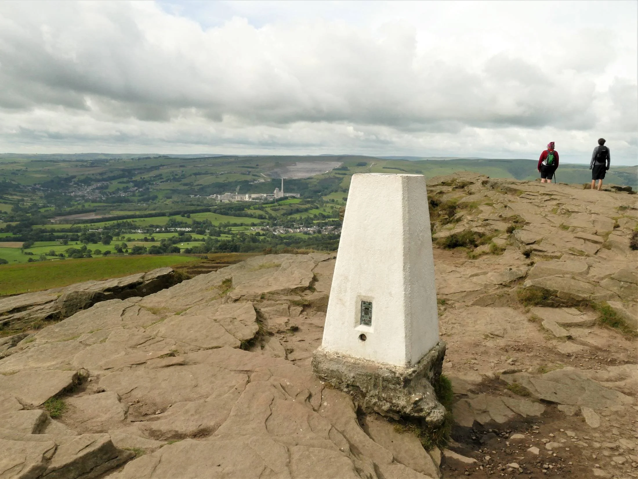

Oh look - lots of issues here! On the plus side, there is no one else around, so those of us who love getting away from it all are very happy. But we did get up early to achieve this. We don’t see this as a problem, however. Self-managing the timing of our access to potentially busy areas is part of the challenge.
But obviously, lots of other people have been here and the photo hints at the erosion that all those walkers have caused. In the early days of the Pennine Way this was a serious problem, and much of the route has been paved to overcome the ‘sea of mud’ crisis. This is a sensible solution, which increases access but does diminish the wilderness feel. I was worried during our recent wet winter that the ‘sea of mud’ look created by a lockdown population desperate to get out and keep sane, would bring out the worst in our open space managers. What a swell of pride when the response was basically, ‘don’t worry, keep coming, we’ll sort it out later’.
And the view? What’s that lurking in the distance, sporting a high chimney and a massive quarry? It’s the Bredon Hope Cement Works, with the village of Hope nestling in the Valley below. The up side? It all started in the late 1920s, long before planning legislation and the designation of the National Park, but environmental control is much stricter now.

Lots of the finished product goes out by rail (left), so minimal impact on road transport.
Provision of local employment - Bredon says the company is ‘the area’s largest employers with the majority of the 200-strong workforce at Hope living in the Peak District’ and that they employ a ‘diverse range of people’. https://www.hopecementworks.co.uk/about/
Down side? Big energy user and lots of CO2 goes up the chimney. Damage to visual amenity? You decide. At this distance, we thought it rather interesting and a demonstration of geography in the raw (the plant is here because the required limestone is here). Living next to it, may produce a different answer, however.
Don’t like it? One of the great 21st century challenges is finding alternatives to, in this case, building materials, to reduce negative impacts. On delving deeper, alternatives can often be worse than the existing situation. Ingenuity essential.
Thanks to Wikipedia for some help with the above. https://en.wikipedia.org/wiki/Hope_Cement_Works

Strines Moor and the real grouse.
Grouse moors: where to start. So many issues, so many points of view.
Shooting and grouse moors were a big part of the original Right to Roam debate. The few owned vast acreages of moorland and denied access to the many. It was still an issue in the CROW Act which does allow for short term closures of open access land to allow for shooting.
You could devote a whole blog to intensive grouse shooting and grouse moor management and indeed Terroir was planning to do this until we came across Guy Shrubsole’s blog post on ‘Who Owns England?’ https://whoownsengland.org/ Do read his January post, entitled ‘The Climate Sceptics Grouse Moor’ which, although a diatribe against one particular moorland owner, gives an overview of some of the issues. Read all his links too, to get a view of both sides of the argument. Both the hunting and shooting orgnisations and the environmental press argue lucidly for and against intensive grouse shooting.
Here is a quick round up of the main issues. We have already mentioned access, so we will move onto the management debate. Rotational cutting, burning and draining of grouse moors is standard practice. If cut back, heather re-grows until it becomes ‘over mature’ - tall and leggy - when, if cut back again, it will restart the growth cycle. Each part of the cycle has its ecological advantages and so it is not uncommon, on any form of heathland, to cut areas on a rotational basis and try to mimic former and traditional management via grazing and burning.


Above - classic pictures of rotational cutting of upland moorland for grouse shooting. The patterns are wonderful and I would happily upholster my sofa in something based on this, but the ecological implications are less appealing.
Grazing and burning of lowland heaths, often in urban areas, is not really attempted any more for reasons of livestock welfare and control and, for burning, for reasons of pollution, and burn control, particularly in areas heavily used for recreation. On upland moorland, the substrate is often peat, which puts a whole different perspective on the matter. Peat is regarded as an excellent carbon store and burning and drainage is seriously damaging to peat. Strines Moor is classified as Upland Heath (https://magic.defra.gov.uk/MagicMap.aspx) which means peat depth may be limited to ‘only’ 50 cms deep, but there is plenty of blanket bog in the area, and the name is an excellent description.
Of course, species conservation and biodiversity is also part of the debate with game keeper and ecologist fighting it out on who can best conserve and manage heath and bog vegetation, ground nesting birds, raptors, butterflies and … . You get the picture.

Tree planting is the other ‘Big One’, which must be discussed.
Deciduous woodland beside Ladybower Reservoir
One of the big upland debates centres on trees. Visitors love the windswept uplands, with their stunning views, ‘wilderness’ experiences and complete contrast to an urban and often industrial home environment. The Forestry Commission loved the open uplands for their unobstructed tree planting options. Don’t forget that the Commission was set up in 1919 after the terrible experiences of WWI, to provide a strategic resource of timber, should such a conflict ever re-occur. Of course, it did re-occur but by 1939 the new plantations were at best only twenty years old and even the fast growing, non native conifers were not of a size or condition to deliver.
Post war, support for planting non-native and non-local timber conifers continued with a mix of enticing tax breaks for those owning large estates, and a range of grant funding. In my view the economics never stacked up, but the promise of jam today more than compensated for the lack of jam/income at maturity and felling. Criticism of the visual impact of the sitka spruce farms and of damage to biodiversity and native habitat became increasingly vocal. To encapsulate over half a century of grumpiness into one sentence, changes were made in planting design, management and species choice, and the governmental approach shifted to include access and nature conservation as prime objectives along with timber production. The grant forms became harder and harder to understand/complete, so just about everyone had something to moan about.


With increased understanding and awareness of climate change, the whole tree planting thing shifted gear once again. Here is a flavour of some of the issues (it’s extraordinarily complex, so please don’t expect a comprehensive run down, details, or academic verification). Trees absorb carbon as they grow, but they grow very slowly. Alternative carbon sinks are available. Managing woodland to create a continuous supply of fuel might be close to carbon neutral, but wood smoke contributes to air pollution and we are already banned from burning ‘wet wood’ (more than 20% moisture content), please note if you own a wood burning stove. Mass tree planting can do more harm than good and this is a serious issue. We were incandescent over an episode of BBC’s Countryfile, which appeared to be supporting mass planting of a single non-native conifer, in Northumberland. I thought we got over that approach last century.
Tree planting will be and should be one of the pieces in the carbon control jigsaw but, as with peat, it’s not as easy as it looks. Tree planting must use appropriate, preferably native - and locally native - species and mixes, or our wildlife and ecology will be sunk. It must also take into account other landuses and habitats, which may actually be more valuable than new tree planting - yes, really - otherwise our ability to sustain, diversify and also feed ourselves will be significantly damaged. It must be in an appropriate place in the landscape, taking into account our love of the hills, views, access, and the needs of human beings, or our history and society will go down too.
To do all of this, we must have appropriate leadership, support and guidance from our government and its advisers. We must learn lessons from the Corona epidemic. And we must do it on a global scale.
End of rant, but it is rather important.
Pond Life
If last week’s blog discussed the environment of Thornton Heath’s present day fishy experiences, then this week’s sequel will focus on a historically watery habitat. We are going from Thornton Heath’s fish shops to Thornton Heath Pond. We will return, via a new open space opposite the station, to complete our circuit.
The maps included in last week’s post clearly show that, in the 19th century, the heart of Thornton Heath lurched eastwards, from the original hamlet around the Pond to the station, and then beyond again to the newly-created, semi-circular High Street. The pulling power of the Victorian railway system was, in all senses of the word, vastly superior to the speed, comfort and carrying capacity of the Victorian road system. Today, of course, road transport is favoured, but it also delivers a significant, negative environmental impact. Thornton Heath High Street, originally a product of train travel, appears to have responded well to regeneration works but what has happened to the road transport dominated ‘Pond’?
It is a good mile from the High Street to the Pond so, after our exploration of Thornton east, we save our legs and take a bus to go west to the Pond. To be honest we got the wrong bus so come upon Thornton Heath Pond from the south rather than from the east.

Approaching Thornton Heath Pond along the old London to Brighton Road you cannot but believe that this vast gyratory will be a polluted, noisy, dusty, litter-strewn, cracked paving, broken tarmac-ed, and unpleasant experience.
© Google Maps 2021

To reach the centre you have, by necessity, to cross busy roads. Threading your way over a traffic ‘skerry’ (island is too comforting and romantic a word) with an untidy growth of poles supporting traffic lights, signposts and cameras, it is at best uninspiring and at worst confusing and downright depressing. The only nod to local identity – a kind of low, urban, metal hurdle adorned with golden baubles and announcing ‘ornton Heath Pond’ - has already been adapted to carry the modern equivalent of fly posting.
Emerging on the other side, there is another scatter of vertical elements and lumpy skerries but the impact is both surprising and altogether more pleasing. Dimensions, materials, spacing and sight lines have created a sense of arrival and of calm. Who would have thought that the centre of a roundabout could become a destination, a place to sit in the sun, a place to watch the shadows etching patterns on the ground, a place to admire the daffodils, tulips, new leaves and blossom. One of the boulders even turns out to be a Croydon Stone.


The remnant of the pond lies at the other end of this almost-bean-shaped traffic island. A path, delineated by low brick walls, offers a pleasant promenade down into the grassy bottom, which is itself edged by further walls or vegetated banks. It doesn’t take much to imagine it full of water. Considerable efforts have been made to decorate the walls, and the perimeter trees on the ‘banks’ provide structure, shade, interest and significantly dilute the impact of the circling traffic (although I might not be saying that during a wet and non-Covid rush hour).


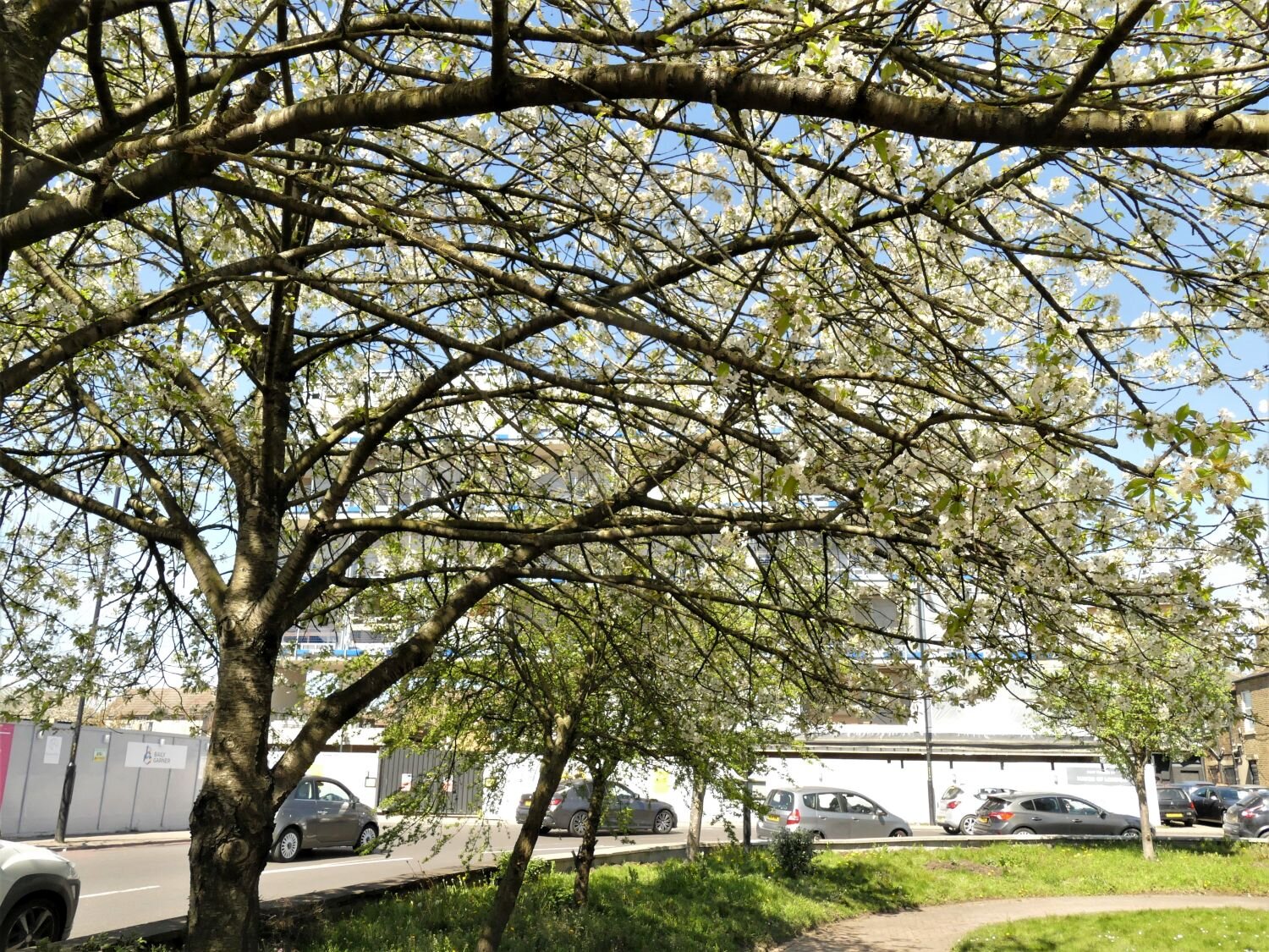
Some would say that the perimeter banks, the planting areas and even the grassed area within the ‘pond’ itself are neglected and weedy, but in spring time we find them totally inoffensive, indeed a real bonus for a heavily urbanised area of south London located in the centre of a roundabout. The impact of a wide selection of native wild flowers, all blooming, all self-generating in their rough grassy matrix, gave enormous pleasure. We logged red dead nettle (Lamium purpureum), groundsel (Senecio vulgaris), dandelion (Taraxacum officinale), shepherds purse (Capsella bursa-pastores) chickweed (Stellaria media), daisy (Bellis perennis), forget-me-knot (Myosotis arvensis or similar garden escape!), yarrow (Achillea millefolium), buttercup (Ranunculus acris) and an umbel which the photographer slipped in without identifying…).
We will revisit later in the year to see how this landscape copes with other seasons.


Also on the plus side, I did find subtle evidence of maintenance. The path edges had been cleared, trees maintained, and there was precious little litter. An extraordinary range of people were either walking though or sitting and enjoying the sunshine and the delights of such an unusual open space. Even the noisy bunch of young men who turned up to sit on the walls were soon relaxing, quietening down and generally merging into the magic of the environment.


Perhaps the lonely, off-centre, tree-less, commemorative planter fails to make the grade. Perhaps the place is a nightmare in the dark, perhaps …. But on that day, in that weather, at that time of year it was an extraordinary, surprising and pleasant experience.
But there is another open space we need to visit before we take the train home.
Walking up Brigstock Road from Pond to Station we pass more street murals which do exactly what they are meant to do and reinforce our upbeat mood.


Opposite the station, we come to Ambassador House. We will let the Thornton Heath Chronicle (online edition, 28/10/18) make the introductions:
‘The iconic Thornton Heath eyesore Ambassador House is being squatted by a collective of artists, The Chronicle can exclusively reveal.
The group of five have taken over the vacant building which has been empty since it was bought at auction in October 2012 by Red Wing Property Holdings Ltd … .
The group wants to open up the redundant office space to the community and has begun putting in place precautions to meet health and safety requirements as well as setting up an account to pay for the utilities.
Ambassador House was was[sic] once a busy hub, with offices used by CALAT, the Met Police, and Croydon council.’
How interesting. But back to the Thornton Heath Chronicle online (6/12/19):
‘Last year the council launched a competition to transform the Ambassador House forecourt.
A year later this is the result – a mural and and an unfinished garden. …
Following the announcement of the winners, a collective of architects, public consultations were held resulting in a grand design. A mural was painted and then months spent creating a garden by the bus stop which is full of weeds …
Then out of no where the forecourt was back in the spotlight. The council had done a deal with Timberland as part of its Nature Needs Heroes campaign with Croydon rapper Loyle Carner declaring plans to green up the area. The forecourt was cordoned off and transformed in to a trendy venue with marquee and a concert stage and the public hurriedly invited on a week day to look at the plans, though to the untrained eye looked much the same plans. …
The latest date to install and launch the square is April 2020. Watch this space!’
So we did watch this space and this is what we found.


It’s bright, it’s fun, it’s brash and in your face. It’s so much better than a weedy bus stop. It’s also lunchtime. Where are the people? It’s pretty much empty. It’s long and thin, and feels tight, small. To us, back from the sunshine over Thornton Heath Pond, it feels drafty, lacking focus and depth. We are probably being very unfair; It’s probably heaving in the sunshine, on a weekday, when there is an event on, when the shops are open. But today? It lacks the spontaneity, the people, the nooks and crannies of the Pond. It feels more like a thoroughfare than a place to linger. The Pond was obviously used as an access - it’s in the middle of four major roads for goodness sake, and walking through is a far pleasanter experience than walking around - but it also felt like a place where you could ‘dwell’ for a moment or for a while.
So, sorry Ambassador House. We want to pick up a wrap or a samosa from one of those exciting shops in the High Street but its too far in the wrong direction, so we’ll find something in equally multi-cultural Broad Green on our way to East Croydon Station. This space is too well-tailored, too sterile for our current needs. Espeially when the station building, wrapped in scaffolding, can’t contribute anything to the street scene either!
So we will bid you farewll with a taste of some of Thornton Heath’s best banners.


An uproar of amazingness
Fish for supper? Fancy a surprising south London suburban stroll? Welcome to Thornton Heath.
The reason we went to Thornton Heath was to look at some art work at the station, of which more later, but having arrived by train it seemed churlish, and unlike Terroir, to go home after just viewing that mosaic on platform 1. So we climbed up to the High Street and spent a few hours exploring the wider suburban landscape. It’s quite an eyeful.

St Alban the Martyr’s Church
Building started in 1889 but contined in stages until 1939. It is listed grade II
Architects: William Bucknall & Sir Ninian Comper
But let’s start by going back a bit. In case you don’t know, and that may be quite a lot of you, Thornton Heath is in south London, just to the north of Croydon. One of the better known local landmarks is Thornton Heath Pond, not because you can picnic or feed the ducks there (you can’t) but because of the adjacent bus depot and the number of red London buses which carry ‘Thornton Heath Pond’ as their final destination. But it does sound delightfully rural, atmospheric and a worthy - if somewhat mythic - destination, just like the Purley Fountain, to the south of Croydon. And, just like the Purley Fountain, Thornton Heath Pond, is now the centre of a very busy roundabout.


In August 2018, the Croydon Advertiser asked the inevitable question, ‘Why is there no water at Thornton Heath Pond?’ (https://www.croydonadvertiser.co.uk/news/croydon-news/no-water-thornton-heath-pond-1939675). Part of the answer went as follows:
‘Centuries ago, before the busy roads were built, Thornton Heath actually was a heath. Acres of common land stretched across the area, and the ancient grazing land was used by Medieval farmers to feed their animals.
Their livestock could also take a drink at the watering-hole at the heart of the heath which would later become the eponymous Pond.
The area – now part of London's most populous borough – was once a rural and isolated spot.’
The London to Sussex Road (now the A23 London to Brighton road) also passed by the pond and is probably the reason the area became famous for highwaymen. An interesting Wikipedia article (https://en.wikipedia.org/wiki/History_of_Thornton_Heath) suggests that Dick Turpin was associated with the area (via a local aunt - families, eh?) and that a ‘plot of land at the Pond became known as Hangman's Acre. Immense gallows loomed on John Ogilby's Britannia maps of 1675, and were still present in a later edition in 1731.’ The account goes on to suggest that in the 17th and 18th centuries Thornton Heath was ‘a desolate valley with lonely farmsteads sheltering desperate outlaws, with the hangman's noose the only recognised authority.’
The other local activity of note is commemorated by Colliers Water Lane, a local street name which still exists, and whose origins were linked to the romantic sounding Great North Wood. Remember, however, that this area is culturally both the south of England and ‘south-of-the-river’, so that the Great North Wood didn’t even get to Watford, but stopped abruptly on the south bank of the River Thames. The Colliers were charcoal burners who, according to the Wikipedia article, burnt timber from the Norwood Hills, using cooling water from the adjacent Norbury Brook. The concept of ‘north’ must have had a deep psychological impact on Croydon and the south. Wikipedia continues, ‘Smoke and high prices made the Thornton Heath colliers unpopular. With their dark [presumably in the sense of grimy?] complexions, they were often portrayed in the popular imagination as the devil incarnate.’
Back to the Croydon Advertiser: ‘In the early 19 century the well-to-do started to build their grand houses along the London Road [or, as William Cobbett described them less politely, ‘stock-jobbers’ houses’] , and the village surrounding the pond began to attract tradesmen.
New tastes and wealthier citizens led to the one-time watering-hole being given an upgrade – formal railings were installed to circle the water-feature, which became the decorative heart of the area.’
What the Croydon Advertiser forgot to mention is that, prior to the 19th century ribbon development, the land surrounding Thornton Heath had been enclosed (in the 1790s), and had become a landscape of small fields, farms, woodlands and the occasional orchard; no doubt very bucolic but enclosure meant that the control of the land would now have been in the hands of a very small number of people.
With the development of the Surrey Iron Railway (Croydon to Wandsworth section) in 1803, and the Croydon Canal (Croydon to New Cross via Forest Hill), in 1809, both passing close to the south of Thornton Heath Pond, plus the existing importance of the London to Sussex road, probably made investment in the Thornton Heath Pond settlement an attractive proposition. Instead of agricultural improvements to his newly enclosed fields, a beneficiary of the enclosures, one Thomas Farley, ‘converted allotments of land and sold them as freehold property. As a result, by 1818, the hamlet around the Pond had become a considerable village containing 68 houses’ (Wikipedia). One suspects that it was not quite the windswept heath which the newspaper report implied.

The sign of the Thomas Farley Public House, High Street, Thornton Heath
The pub has closed but, perhaps appropriately, has been converted into residential accommodation.
But it was the Victorian railway boom which initiated the major conversion of Thornton Heath from urban fringe to full on south London suburbia. Where railway lines had not been routed through existing settlements, stations such as Thornton Heath (constructed in 1862) were built in the middle of farmland. Again, those who had done so well out of the enclosures, recognised that they were sitting on prime real estate and, within ten years, the area of housing around the station was larger and more significant than the road hub, almost a mile away, around the Pond.
The maps below tell their own story, with the railway stimulating residential development far more rapidly around the station than around the pond/village/highway combination.

Ordnance Survey 1894/95 Revision, showing both pond and railway station
Pond - blue circle Station - red circle


All map images 'Reproduced with the permission of the National Library of Scotland' https://maps.nls.uk/index.html
21st century Thornton Heath has a far more diverse demographic than the community which formed around the station in the late 18th century. But times are tough and, in 2010, most of the area between and around the station and the pond was recorded as lying in the more deprived end of the multiple deprivation spectrum. By 2015, the situation worsened but some improvement is shown in the 2019 statistics. Indeed Croydon Council has been working on the regeneration and improvement of the Thornton Heath environment since 2016 and around £3 million pounds has been invested, on shop and building front improvements, on artworks and on open space. The methodology behind this work deserves a blog in its own right but, for now, Terroir will take you on a tour of the delights of Thornton Heath and try to demonstrate why we so enjoyed our morning of sight seeing.
If you arrive by train, look out for two things.

The first, left, delivers a bit of a mixed message.
We are happy to be welcomed to Thornton Heath, but are wary of the anti-climbing device on the top of the wall!

This, right, is what we have actually come to see.
It is one of 14 such roundels currently adorning 11 stations around London.
The roundels are the work of Artyface, founded by Maud Milton in 1999, ‘to provide high quality, legacy public art’ with community involvement at its core. Her website is a delight (https://artyface.co.uk/wp/) and if you ever need cheering up, just take a browse.
The Station roundels project was developed out of a partnership with Arriva. Maud and team worked with 3,000 members of the relevant local communities to create the designs for the first 13 roundels which are all noth-of-the-river, mainly on the London Overground.
The most recent roundel has been devloped for Govia Trains and the Thornton Heath community. The detail is phenomonal and tells its own story.


Leaving the station for our ‘well we might as well take a look while we’re here’ expedition, we turn to the left to head east - away from the Pond. Turning around to take a photograph of the 1860s station building, we are gutted to find that it is encased in the warm embrace of extensive scaffolding. A bad start for the photographer.
Our next discovery was the clock tower and the Croydon stones. The clock tower, which also seems to feature as an iconic bus stop, in a similar manner to the Pond, was erected in 1900 to celebrate the new century. According to the Thornton Heath Chronicle, it suffered a minor arson attack last year but appeared, to Terroir, to be in good condition last Saturday. Neither were there any signs of the ‘street drinkers’ who the Chronical reported to have been plaguing the area.
Left: the Thorton Heath Clock Tower
Below: one of the Croydon Stones


After this sedate history lesson, things really began to hot up as we rounded the corner and moved onto the High Street. It was a blast - first the murals, then the building facades, and then the shops themsleves.


We turned off up a side road, to see what went on behind the behind the High Street and were taken aback - again - by the extraordinary contrast offered by the suburban streets. How could anywhere so close to that vibrant, brightly coloured and noisy high street be so quiet and so calm. We could hear the birds singing and we couldn’t hear the traffic. How is it done?
We walked up hill, discussing how we would like to live here, as long as there was a park or open space nearby. As if by magic, we came across the entrance to Grangewood Park. As we entered, the magic did rub off a little, however, as the steep gradient put paid to our day-dreams of spending our twilight years here. If any octogenarians were to make it their daily walk, they would certainly be very fit. Grangewood Park is a relic of a much older estate which was originally part of, guess what? the Great North Wood (https://www.thorntonheathchronicle.co.uk/wp-content/uploads/2020/04/Grangewood-Booklet-v6.pdf). Today the southern lodge is boarded up, the scattered trees look tired (and what is that tent doing in the second picture from the left?), the ground flora is trampled down and the soil looks heavily compacted. Spring seems a little far away, although a Monkey Puzzle tree and some sparkling new gym equipment do lift the spirits.


We zig-zagged back through more amazingly peaceful - and clean - streets, spotting our favourite bits of suburban architecture.


Back on the High Street, we had to face up to the big question. Why were there so many fish shops? We don’t mean fish and chip shops or fish restaurants, we mean wet fish shops, fishmongers, shops that sell fresh fish. Some just sold fish, some sold fish and a variety of groceries or vegetables. We wouldn’t have been surprised if the newsagents had had a fish counter. Why is Thornton Heath fish heaven? If you know please put a comment at the bottom of this blog.
Talking of which, we will postpone the rest of our voyage through Thornton Heath until next week, as there are one or two suprises still to come. But we will leave you with an image of that evening’s supper. It was by far the best fish we have had in ages.

Home Ground
An Englishwoman, an Irishwoman, a Welshman and a ‘British’ woman were all sitting around their respective dinner tables having a Zoom meal. It was the time of the Rugby Six Nations tournament and the conversation between the Welsh and Irish contingent was animated, emotional, patriotic, fervent and loud. Suddenly Irish turned to English and asked why we didn’t exhibit the same degree of loyalty to England. There was quite a long, deep pause as we marshalled our thoughts.
While we are waiting, I will just mention that the ‘Briton’ present is so-called because she is linked by birth, domicile, emotional connections and genetics, not only to Surrey, but also to the Isle of Wight, Yorkshire and Ayrshire. In the interests of balance she is often pigeonholed as the token Scot, but on this occasion she adopted an English perspective (current domicile and birthright). As another aside, we are all white and British or Irish born.
Much of what came out of the pregnant pause will be picked up again in future blogs. I’m referring to things like never thinking we were the underdog, not having to fight for (in this case) Celtic identity, culture, language or independence; things like guilt over the empire (so often identified with the English if not, actually, factually correct); things like the adoption of the cross of St George by football fans; things like being economic migrants within our own country and having lost our roots or strong feelings of identity for a particular region.
The final question, from Ireland, was, ‘Well, where is home for you, and with what area do you identify?’ It was a sudden, light bulb moment for England. The answer is Kent. It is the land of my fathers (most of my mothers came to London from the Midlands). Kent is not known for its prowess in rugby, but it is where I instantly feel at home and is the only county where I don’t have to spell my surname.


As a child I visited deepest Kent regularly. We were allowed free range of the local countryside as long as we rocked up at our grandparents’ cottage in time for meals. Somehow, I absorbed an innate emotional, ecological, botanical, geographical, historical, architectural, cultural, literary, agricultural and (being Kent) horticultural afinity, and a deep appreciation of Kentish landscape and community. Many, many years later, on a visit to Hughenden Manor (which is in Buckinghamshire), we walked down an avenue of beautiful coppiced hazels. I instantly felt a warm rush of comfort and nostalgia for Kent. I instinctively knew their shape and form and what they stood for in the history of the Kentish landscape. You may think this is bizarre, but it was a wonderful feeling of coming home. Snowdonia does it for the other half of Terroir. So it’s not romantic tosh after all?

Coppiced hazels used as an ornamental avenue along the drive to Hughenden Manor
The hazel coppice, backed by the brick and flint wall, could easily be taken for a Kentish ensemble, rather than the entrance to Benjamin Disraeli’s home near High Wycombe in Buckinghamshire
This feeling was revived, when we went for a walk in a National Trust Woodland on the Surrey side of the Kentish border. No, we’re not purists; English Terroir feels pretty comfortable in Sussex and the Kent/Sussex/Surrey borderlands too, despite greater difficulties in surname spelling.
Walking into Hornecourt Wood feels like slipping on a favourite old glove and, in landscape terms, you instantly recognise every aspect of the history and ecology of the space around you. But you don’t have to be a local or an ecologist to appreciate the delicate beauty of a deciduous wood in spring. The wood anemones were at their best, low-lying but proud, massed but not in your face, stunning but delicate. The beefier bluebells were doing their best to catch them up and already a blue miasma was creeping over the ground, but the bridal wind flowers (Anemone nemorosa) were the stars of the show.
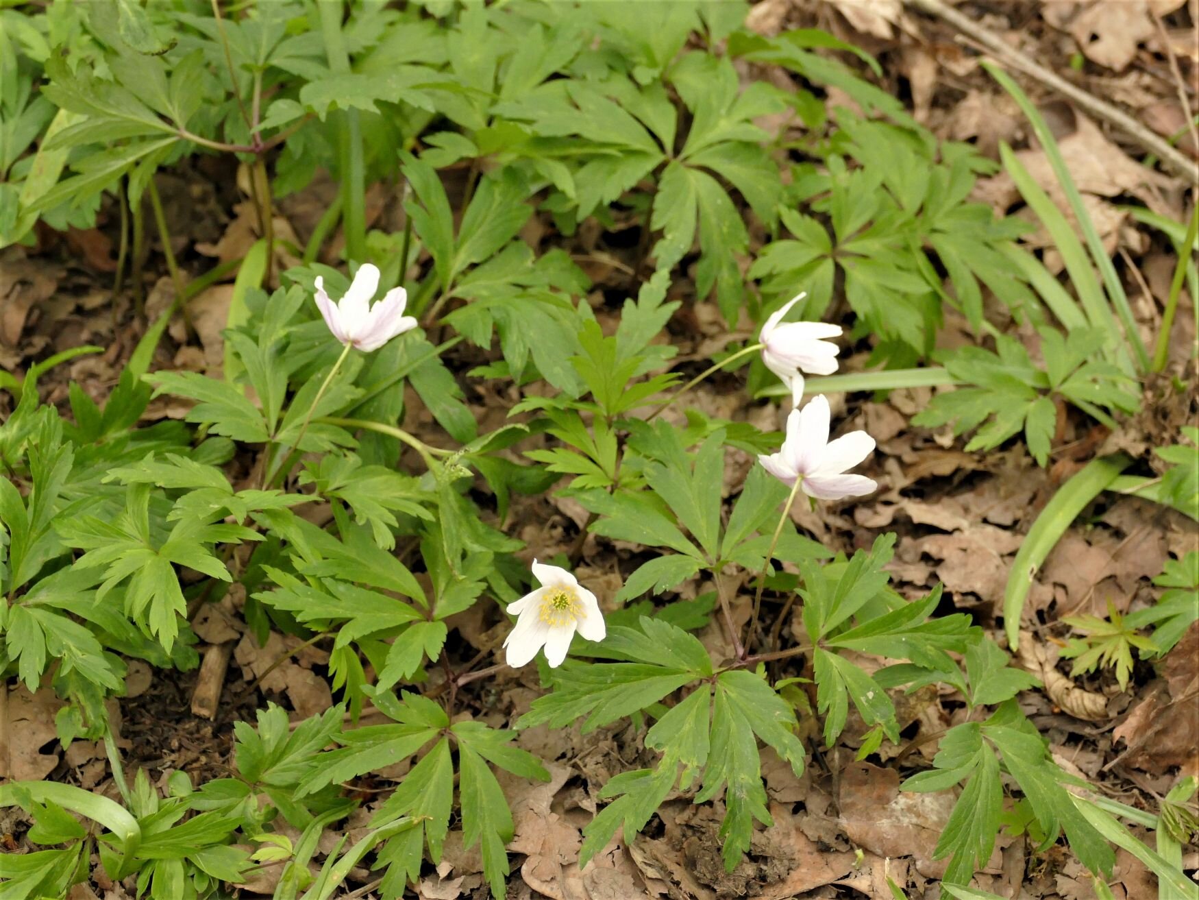

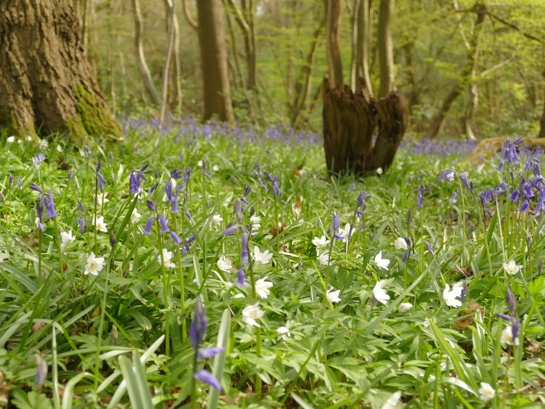
This is ancient semi-natural woodland, defined by being consistently shown as woodland from the earliest maps to the present day (1600 is taken as the starting point). At Hornecourt, it’s a southern classic: a mix of hornbeam which is easily coppiced to provide small ‘round wood’ for poles, fencing, hurdles and so on, and, at a lower density, oak ‘standards’ which grow up as single massive stems to provide construction timber. It’s been a while since that management system has been in operation in Hornecourt, and the hornbeams are growing bigger while the oaks are falling, creating a horizontal sculpture park, studded with their star-like roots. Even the occasional hornbeam has toppled over.


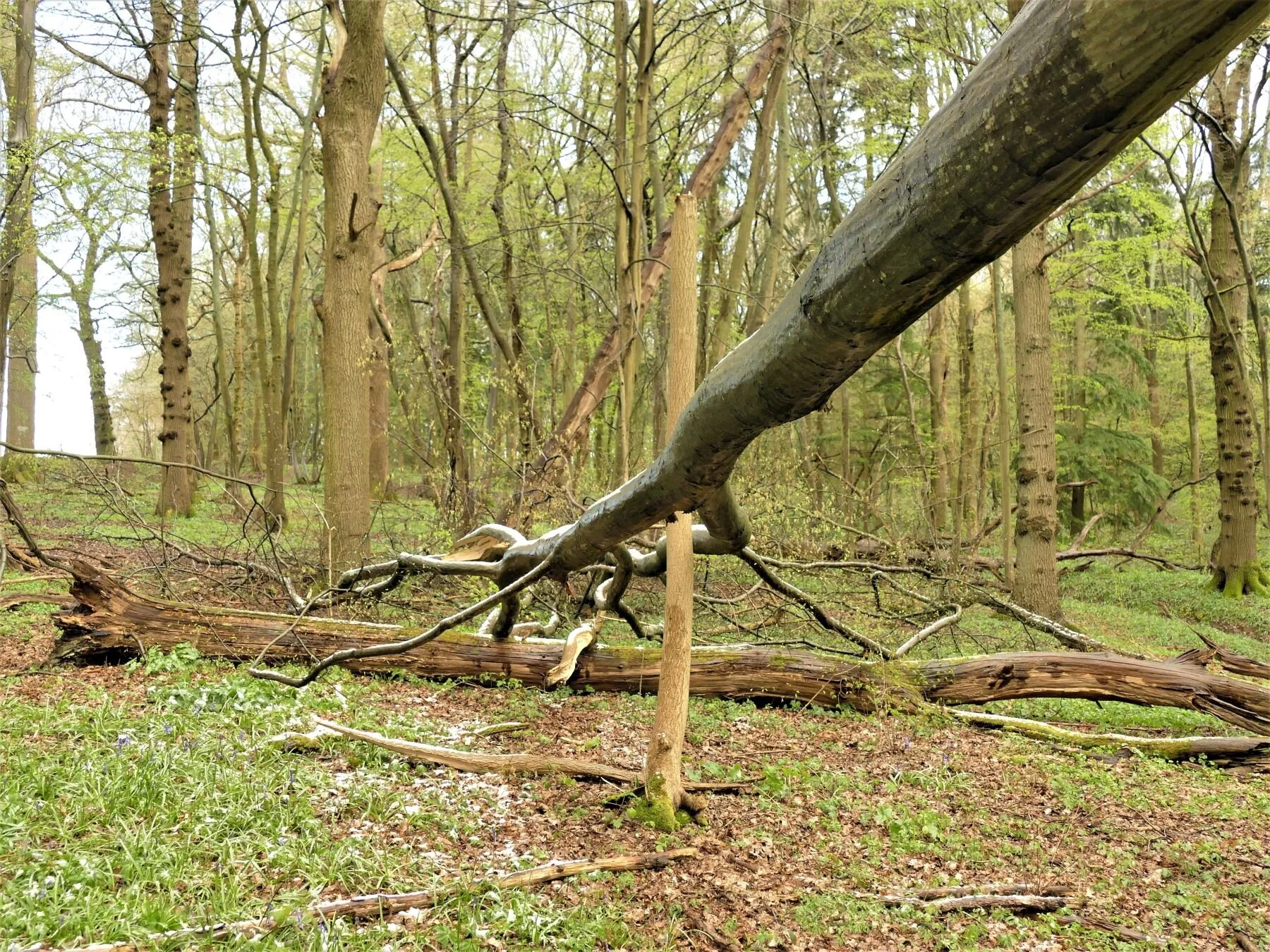
The sculpture park effect is also turned to vertical effect by many of the standing oaks displaying a spectacular range of burrs which are outstandingly visible in springtime.


The hornbeam is as delicate as the wood anemones at this time of year and their opening buds are hanging down like tiny, lax, cocktail umbrellas, while their catkins fatten, lengthen and release their pollen, to the disquiet of Terroir’s hay fever sensitive receptors.


Hornbeam bark is smooth to the touch, a simple garment, elegantly worn.
Hornecourt Wood isn’t all fairy glades, catkins and picturesque burr oak, however, and its topography hides some interesting and alternative evidence of former times. As background, you should know that the wood is just a small part of a large agricultural estate, donated to the National Trust around the middle of the last century; there are five main farms spread over three parishes. To a public which is used to the Handbook listings of heritage buildings and spectacular countryside, this is a side of the National Trust which is less well known. The estate is located in the farmlands of the Low Weald and the wood tumbles down a low escarpment to the sticky clays of the Weald below. A classic Wealden gill also tumbles through a steep-sided valley within the wood, and low-key plank bridges provide pedestrian access.


But there are warning signs of alternative or additional uses. It’s like stubbing your toe on a stone which shouldn’t be there. A rhododendron clump and a few cherry laurels are out of character; stands of birch regeneration, standing out like sore thumbs, have probably taken root in an area cleared but not restocked; there is the shock of an inner core of conifers, including what looks to me like western red cedar, a native of the Pacific coast of north America; new plantings of native hardwoods stand in regimented rows, even-aged and as yet un-thinned – the tell-tale tree shelters still lurking in the light-loving bramble undergrowth.


A quick chat with the National Trust confirms these findings. Apparently the wood was once managed for pheasant rearing – no doubt as an additional source of income at a time when local biodiversity was not sufficient justification in a working landscape. Pheasants are not lovers of draughty copses and the laurel may have been encouraged to provide cover and shelter.
The Trust experimented with ‘commercial’ plantings of conifers again, no doubt, following the practice of the time and chasing the available grants. Thankfully, they were limited to the interior of the woodland and the gill valley, no doubt to conserve the visual amenity of the ancient wood within the landscape.
Again, management aspirations and grant funding changed and much of the coniferous timber appears to have been felled to be replaced by native hardwood species, with the pioneer birch trees leaping in to colonise peripheral open spaces. No doubt the pandemic has entirely destroyed the timetable and budget for any plans to manage these young trees, such that they can integrate into the classic habitat which gives the rest of the wood its richness and beauty.
The National Trust has Terroir’s every sympathy. Woodland management is wonderfully rewarding on all fronts except financial. Until we can adopt a Natural Capital approach, whereby the ‘stocks’ and flows’ of natural resources and services can be assessed in monetary terms, and accounted for on a par with traditional evaluations of goods and services, mangement of magical places such as Hornecourt Wood will be an uphill (pun intended) struggle.
Terroir will leave you with two thoughts. The Zoom dining quartet (particularly the Celts) wish it to be known how much they appreciate living in England, despite their apparent fierce attachment to their mother lands!
Meanwhile those with a fierce attachment to their English forefathers delight in the sculptural impact of the historic remnants of a neglected, south east English, hornbeam-and-hawthorn hedge.


The Art of Lockdown
One of the inspiring experiences of lockdown has been the artistic endeavours of friends, family and colleagues, and it is with great pleasure that I have ‘curated’ (how posh) an exhibition of their works completed during the last 12 months. Some of the contributors have been creating artwork for many years, some only started in lockdown. All have been working within the confines of a pandemic. Many have sold their art at open studio or similar events, but the majority would probably classify themselves as producing art for the sheer pleasure of creativity and, for some, for the adventure of exploring their own artistry as a response to Covid-19.
The experience of curating turned out to be terrifying. I looked up the definition of the expression ‘to curate’ something, to see what it was that I was trying to do. Words such as select, organise, look after, present, interpret and display came up again and again.
Selection has been easy and involved emails to friends and colleagues who I knew were painters or artists. My brief asked for ‘something that you might have created over the last year which has some relationship to landscape, environment or society, however tenuous’. Thus the process of selection of the potential artists was down to me. The selection of the artworks, was (largely) down to the artists. I have accepted everything which was sent me. I was aware that some I contacted had been involved in portraiture but, knowing my background, they felt that the link to ‘landscape and society’ was just too tenuous; thankfully I managed to convince one artist that portraits are important too.
It was the requirement to organize, look after, present, interpret, and display which was so stressful. My own creative experience relates to working with actual, live landscapes. This can be onerous: the responsibility of creation must be taken seriously, and comes with responsibility to client, user and environment. But the curating or management of that landscape is also, in my experience, a joy which brings immense satisfaction. So why the tears and fears connected to this blog’s endeavours? One dictionary defintion continued: ‘typically using professional or expert knowledge’. Ah. So obvious. I am trained to handle landscapes which are alive in a biological sense and are physically anchored into our external environment (I can even handle the occasional house plant) but am a total amateur in curating artistic representations of and refections on ‘landscapes, environment and society’.
So, forgive me if I have made a poor job of exhibiting my friends’ and colleagues’ work. Not only am I inexperienced in presenting and displaying artistic output, but am constrained by the technlogy of a blog platform, on which my grip is tenuous to say the least. If admiration and enthusiasm were enough, then this would be a superb ‘exhibition’, but I know that in the curating sense this is not true! Please enjoy as best you can. My contibutors deserve better but I also know that, despite my ineptitude, their art will speak out for them.
Elizabeth Ellison
Regular walks started last year, usually walking up and over/under the A264, and the railway line, towards the farmland, and Rusper. I took photographs, (too cold to sit about) and resolved to paint small and fast, so no dithering or overworking. Found it helped to prepare sketches, mix all the paint first, and allow myself no more than 40 mins. Nothing too challenging or long term, but as they say, you have to put the paint on!!
Oil paint on board, palette knife
Size 24x18cms
Prepared throughout 2020

March
April

May

June

July

August
Carole
Instagram: @calligraphysurrey
I belong to a calligraphy group and last year the theme for our summer project was ‘CELEBRATE' and the format was a folded book made of a single sheet of paper. I wanted to use the letters of the word ‘celebrate’ but also wanted to specify what I wanted to celebrate. As lockdown happened about the time I started thinking about the project, I chose to celebrate trees, as they became my close companions during lockdown walks.
The large colourful letters spell tree names starting with the letters C E L E B R A T E and although I tried to use mainly native trees, a eucalyptus managed to sneak in.
The tree names were written first with a chisel brush and gouache paint. Then I folded the sheet of paper into its book shape and on each page I carefully wrote a different tree quote in pencil.


Gwilym Owen
I signed up to a lockdown art class, to do something, to motivate myself to attempt some art, and maybe to learn some new skills. I painted from photographs.

Fly Agaric Toadstool
Watercolour on paper

Starling
Water colour on paper

Stanage Edge, Peak Distict
Pen and ink on paper
Maureen Ford
Instagram: @maureen_ford22
Redhill redevelopment during lockdown. Charcoal drawing on paper.

The building site was a mass of linear, vertical, horizontal and diagonal lines and structures with contrasting tones. Having sketched the demolition of the Co Op store decades ago I couldn't resist taking multiple photos and sketching this view.

The painted version is executed using acrylic paint on paper emphasising the contrast of cold greys with the warm colours of the plant.
These are two of the portraits made during lockdown when Clive Myrie and Lesley Garrett engaged in fascinating conversations while sitting for Skye’s ‘Portrait Artist of the Week’ on Sunday lunchtimes. The portraits were fascinating, challenging and demonstrated a wealth of talent by participating artists who shared their work online. portrait artist of the week skye arts

Lesley Garrett, Pastel pencil on paper
[A Yorkshire phenomenon, ed]

Clive Myrie, watercolour on paper
Born on the ‘other side’ of the Pennines [ed]
Walking the footpaths and fields during lockdown and watching the seasonal changes to the fields brings a stability to the everchanging scenario of lockdown.
The sheep are moved to different fields when the foraging becomes scarce. Each sheep has a character of its own, be it curiosity or resignation.

Sheep in a turnip field.
Pastel pencil on paper.
Locked in or locked out?!

Reminders of a bright hot summer
Acrylic paint on paper
Zosia Mellor
I retired from practice as a Chartered landscape architect and have thoroughly enjoyed having time for pastimes. I really enjoy painting …! Before lockdown we travelled a great deal, however last year I did enjoy exploring different corners of England.
Landscape:

Darenth Valley in Kent
Fresh Food in Lockdown

Blackheath Farmers Market
: the market ran throughout both lockdowns and it was a wonderful outlet on a Sunday morning. I was struck by the vibrancy of the colours of this vegetable stall and the jumble of shapes and textures.
This painting is acrylic on board measuring 30 x 20 cms.

Field Mushrooms
: during lockdown walks for exercise I collected these field mushrooms. I enjoy painting seasonal subjects and lockdown has definitely heightened my awareness of the changing seasons.
I used acrylic paint on acid free card measuring 30 x 20 cms.
Rob Thompson
I wasn’t sure if I should include more of Rob’s work (see Blog 18 Cynefin), not because I was worried about over exposure (!) but because in my view he sells enough of his work to make him a professional. Rob thinks this is very funny. So Terroir has compromised and we are pleased to include some paintings he produced to support Snowdonia Donkeys, a charity dedicated to promoting human and equine health and well-being, through working and walking with donkeys. https://www.snowdoniadonkeys.com The two images below were created for, and donated to, a secret post card raffle. If you were generous enough to donate to the raffle and received either of the donkeys shown below, please let us know!


Before you go… thank you so much to all our contributors. When we started working on this blog post, Terroir had no idea just how rewarding, stimulating and throughly enjoyable this curating business was going to be. I hope you - our readers - are able to enjoy this lockdown art as much as we have.
… don’t forget to visit the gift shop! Most of the art shown above is for sale and, if you like their style, the artists also have a store of other treasures. If you are interested, contact Terroir at blogterroir.net@gmail.com and we will pass your details on to the relevant artist or atists. This aspect of producing art was never mentioned in the definitions of curating, and Terroir certainly didn’t embark on this project with this in mind. But, if any of our artists are starving in a draughty garret, we are very pleased to help!!